History in Structure

Former Meeting House to left of Gladestry Post Offcies

A Grade II Listed Building in Gladestry, Powys

More Photos »
Approximate Location Map
Large Map »

Coordinates

Latitude: 52.1891 / 52°11'20"N

Longitude: -3.1237 / 3°7'25"W

OS Eastings: 323276

OS Northings: 255133

OS Grid: SO232551

Mapcode National: GBR F1.47S9

Mapcode Global: VH69Y.S7ZP

Plus Code: 9C4R5VQG+JG

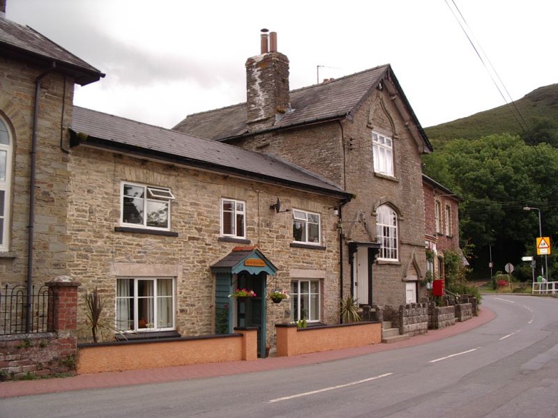
Entry Name: Former Meeting House to left of Gladestry Post Offcies

Listing Date: 21 September 1962

Last Amended: 31 January 1995

Grade: II

Source: Cadw

Source ID: 8775

Building Class: Domestic

Also known as: Former Meeting House to Left of Gladestry Post Office (Formerly Listed as \"The Shop\"), B 4594 (N Sid

ID on this website: 300008775

Location: Village centre, fronting through road 200 yards NE of Parish Church.

County: Powys

Community: Gladestry (Llanfair Llythynwg)

Community: Gladestry

Traditional County: Radnorshire

Tagged with: Chapel Architectural structure

Find accommodation in
Gladestry

Exterior

C18 and mid C19 with Gothick detailing. Formerly the Meeting House of a Friendly Society, The Loyal Order of Ancient Shepherds, and in 1840's used for Baptist services. Coursed rubble blocks, two rubble side stacks, slate roof, deep-set eaves, decorated bargeboards and eaves brackets. Openings under elaborate ogee hood moulds. Two large central windows, the upper one modern, the lower one original, multi-paned iron frame in timber surround. Recessed modern door to left up steps, boarded basement door to lower right. In apex, plaque showing the sign of the Lodge, a heart within a hand.

Reasons for Listing

An unusual building in a small village location.

External Links

External links are from the relevant listing authority and, where applicable, Wikidata. Wikidata IDs may be related buildings as well as this specific building. If you want to add or update a link, you will need to do so by editing the Wikidata entry.

Recommended Books

Other nearby listed buildings

  • II Old Tithe Barn (belonging to Gladestry Court)
    Prominently sited 50m to NE of the parish church.
  • II Gladestry Court
    Prominent village location on S side of main through road, 150 yards E of parish church. Marked on 1839 Tithe Map as Great House, on site of Manor House.
  • II Corner House
    Lies 35m E of the Parish Church in village centre, set back from main through road.
  • II Detached former Smithy Range (near The White Heart)
    Set into bank 20m SE of Parish Church, abuts churchyard.
  • II The White Heart
    Set into bank 20m SE of Parish Church, abuts churchyard.
  • I Parish Church of St Mary
    Situated in open churchyard above B4594, on NW side of village centre.
  • II* Stone House
    Elevated position 800m SE of Gladestry. The first Radnorshire property to be acquired by James Watt. He purchased it in 1798 from Thomas Harley of Berrington Hall.
  • II Foyce
    Lies about 800m NW of Gladestry and reached along by-roads running N from the junction at Gladestry Church.

BritishListedBuildings.co.uk is an independent online resource and is not associated with any government department. All government data published here is used under licence. Please do not contact BritishListedBuildings.co.uk for any queries related to any individual listed building, planning permission related to listed buildings or the listing process itself.

British Listed Buildings is a Good Stuff website.