Latitude: 52.2387 / 52°14'19"N
Longitude: -3.152 / 3°9'7"W
OS Eastings: 321428
OS Northings: 260685
OS Grid: SO214606
Mapcode National: GBR F0.10RK
Mapcode Global: VH69K.BZ0N
Plus Code: 9C4R6RQX+F5
Entry Name: The Grove
Listing Date: 29 April 1993
Last Amended: 29 April 1993
Grade: II
Source: Cadw
Source ID: 9215
Building Class: Domestic
ID on this website: 300009215
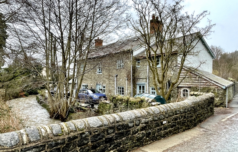
Location: Situated on the east side of B4372 just south of the Summergil Brook.
County: Powys
Community: New Radnor (Maesyfed)
Community: New Radnor
Locality: Grove Bridge
Traditional County: Radnorshire
Tagged with: House
Mid C19, two-storey detached house. Lower two-storey service range adjoins to left and single-storey wash-house adjoins to right. Coursed rubble blocks with low plinth, slate roofs, boxed eaves, two brick end stacks. Central, part-glazed door to south (garden) front with plain doorcase, pediment and over-light. Ground-floor windows are later in date with canted bays having fine margin-glazing. First-floor windows are twelve-pane sashes under flat voussoir lintels. Rear elevation has variety of windows including some original three-light iron-framed casements under similar flat lintels, also tall round-headed stair-light with fan tracery. The richly moulded six-panel door in the rear wall is re-used from elsewhere. Roof lights and dormers are modern.
Staircase with curtail steps, scroll newel, ramped, rounded handrail and stick balusters. Some six-panel doors.
External links are from the relevant listing authority and, where applicable, Wikidata. Wikidata IDs may be related buildings as well as this specific building. If you want to add or update a link, you will need to do so by editing the Wikidata entry.


Other nearby listed buildings