Approximate Location Map
Large Map »
Latitude: 51.8207 / 51°49'14"N
Longitude: -4.0072 / 4°0'25"W
OS Eastings: 261755
OS Northings: 215472
OS Grid: SN617154
Mapcode National: GBR DV.WJPC
Mapcode Global: VH4J9.HHFL
Plus Code: 9C3QRXCV+74
Entry Name: Llandybie National School
Listing Date: 12 October 1972
Last Amended: 27 August 1999
Grade: II
Source: Cadw
Source ID: 11118
Building Class: Education
ID on this website: 300011118
Location: At the west side of High Street, within a large playground. About 100m south of the Parish Church.
County: Carmarthenshire
Town: Ammanford
Community: Llandybie (Llandybïe)
Community: Llandybie
Locality: Llandybie village
Built-Up Area: Llandybie
Traditional County: Carmarthenshire
Tagged with: School building
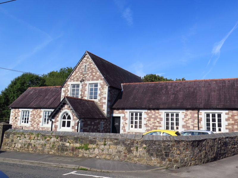
Built in 1849 to the designs of (Sir) George Gilbert Scott (architect to the National Society), at the cost of £656. The site was granted by Lord Cawdor at an annual rent of 1s (5p). The mason was Richard Bowen of Penygeulan. Opened by April 1851 as the National School. Under the Education Act of 1870 an infants' department was added: on the OS map of 1876 the school is marked as a school for boys, girls and infants. The school was closed in 1971 and converted to a Church Hall; the right wing is now a library.
The original school consisted of a two-storey central block with gable to the front, plus entrance porch, with a single storey wing to left and another to right. Before 1876 a rear wing was added at right angles to the left wing and c1911 a parallel rear right wing (architect W D Jenkins, Llandeilo). Kitchen and latrine additions were made c1935 (architect, W. Owen, Neath).
A bellcote formerly stood on the front gable end of the main block.
A symmetrical composition with a slightly projecting two-storey, two-window gabled main range in centre, flanked by a single-storey wing to each side. Multi-coloured masonry of coursed stone: local stone, millstone grit, limestone and red sandstone. Painted limestone quoins. Slate gabled roofs with tile ridges. Pierced and cusped barge-boards survive at the original right wing and the additional rear facing wing.
Square-headed windows of three lights in the flanking wings: two windows in wing to left of centre, and three windows in wing to right of centre, the latter with a parallel range behind. Centre cross-wing has two-light windows on first floor with loop above and a three-light window to left hand on ground floor; gabled porch projection to right hand on ground floor with cusped barge board and two-light window with Y tracery and with entrance in left hand return.
The original upper storey of the main block has been dismantled. Short corridor joins the two right wings outside the main block.
A large early village school, to the design of George Gilbert Scott, retaining its simple Gothic character.
External links are from the relevant listing authority and, where applicable, Wikidata. Wikidata IDs may be related buildings as well as this specific building. If you want to add or update a link, you will need to do so by editing the Wikidata entry.


Other nearby listed buildings
