History in Structure

The Mill House, Llandybie

A Grade II Listed Building in Llandybie, Carmarthenshire

More Photos »
Approximate Location Map
Large Map »

Coordinates

Latitude: 51.8211 / 51°49'16"N

Longitude: -4.0043 / 4°0'15"W

OS Eastings: 261956

OS Northings: 215512

OS Grid: SN619155

Mapcode National: GBR DV.WKDG

Mapcode Global: VH4J9.JHY8

Plus Code: 9C3QRXCW+F7

Entry Name: The Mill House, Llandybie

Listing Date: 12 October 1972

Last Amended: 27 August 1999

Grade: II

Source: Cadw

Source ID: 11120

Building Class: Industrial

ID on this website: 300011120

Location: To the east of Llandybie mill. Stone rubble enclosing wall (modern concrete blockwork to street side) with steps down to the mill yard.

County: Carmarthenshire

Town: Ammanford

Community: Llandybie (Llandybïe)

Community: Llandybie

Locality: Llandybie village

Built-Up Area: Llandybie

Traditional County: Carmarthenshire

Tagged with: House Mill

Find accommodation in
Llandybie

History

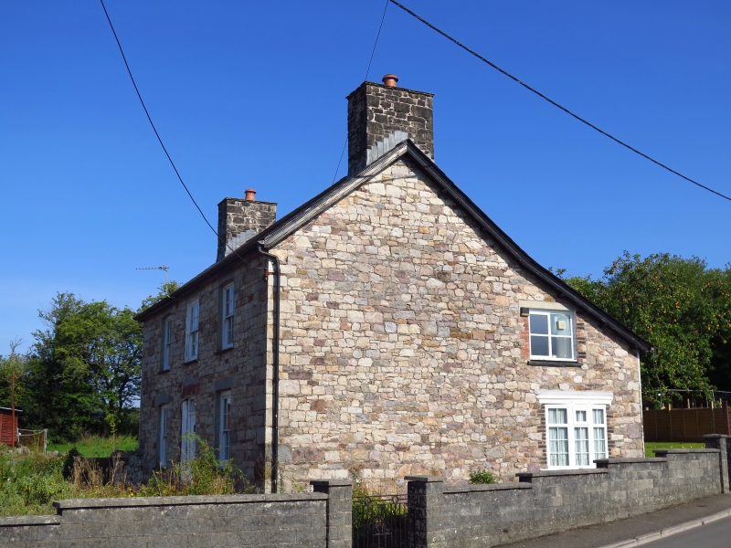
Small house with an early C19 front, though the large chimneys suggest an earlier date; perhaps C18. In 1840 it was recorded as mill, homestead and waste in the occupation of Evan Evans.

Exterior

A two-storey, three-window miller's house facing west towards Llandybie mill. Whitewashed stone at front and side, the front in axe-dressed masonry, the side in rubble; rough-cast at rear. Slate roof with tile ridge, timber bargeboards; large rendered end-chimneys. Gabled roof carried down to a catslide over the rear extension. Sash windows of twelve panes, exposed frames, horned sashes; panelled door with overlight and slightly cambered head. Modern door and windows at rear.

Reasons for Listing

A fine miller's house retaining good C19 character and forming a group with the mill.

External Links

External links are from the relevant listing authority and, where applicable, Wikidata. Wikidata IDs may be related buildings as well as this specific building. If you want to add or update a link, you will need to do so by editing the Wikidata entry.

Recommended Books

Other nearby listed buildings

  • II The Mill, Llandybie
    Beside Afon Marlais to the north east of Llandybie Bridge. Former miller's house immediately to its east.
  • II Llandybie Bridge
    At the crossing of Church St / King's Road over the Afon Marlais in Llandybie village.
  • II Stone Spheres at Entrance to PLâs Llandybie
    At the entrance to the village-centre site of the former Plâs. About 30m west of Llandybie bridge, at south side of street.
  • II* Church of St. Tybie
    At the centre of Llandybie village. Large stone-walled graveyard to north side (recent parts walled in concrete blocks). High wall with steps and iron gates from the street at west and south; stile be
  • II Llandybie National School
    At the west side of High Street, within a large playground. About 100m south of the Parish Church.
  • II The Red Lion Inn
    At the south side of Llandeilo Road, about 50m west of the Parish Church.
  • II Agricultural Range Opposite Red Lion Inn
    Detached immediately opposite the Red Lion Hotel, on the northern edge of Llandybie; farmyard to rear and to left.
  • II American Villas
    At west side of Ammanford Road, between the Afon Marlais and Rawling Road.

BritishListedBuildings.co.uk is an independent online resource and is not associated with any government department. All government data published here is used under licence. Please do not contact BritishListedBuildings.co.uk for any queries related to any individual listed building, planning permission related to listed buildings or the listing process itself.

British Listed Buildings is a Good Stuff website.