History in Structure

Crown Inn

A Grade II Listed Building in Town (Y Dref), Merthyr Tydfil

More Photos »
Approximate Location Map
Large Map »

Coordinates

Latitude: 51.7438 / 51°44'37"N

Longitude: -3.378 / 3°22'40"W

OS Eastings: 304956

OS Northings: 205905

OS Grid: SO049059

Mapcode National: GBR HN.1C1X

Mapcode Global: VH6CY.DFKL

Plus Code: 9C3RPJVC+GR

Entry Name: Crown Inn

Listing Date: 13 January 1988

Last Amended: 13 January 1988

Grade: II

Source: Cadw

Source ID: 11436

Building Class: Commercial

ID on this website: 300011436

Location: Towards the S end of High Street where road narrows.

County: Merthyr Tydfil

Community: Town (Y Dref)

Community: Town

Built-Up Area: Merthyr Tydfil

Traditional County: Glamorgan

Tagged with: Building

Find accommodation in
Merthyr Tydfil

History

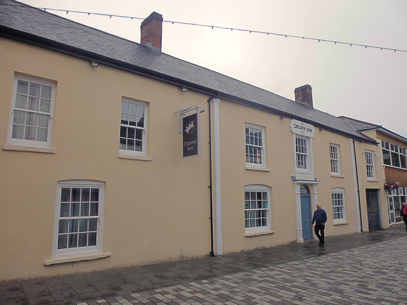
Dated 1785, later alterations.

Exterior

Long 2-storey simple Georgian front of painted render with incised coursing, simplified pilasters. Steep slate roof with two tall brick stacks, boarded eaves. 6 windows, replacement sashes with small glazing bars, deeper reveals on left; centre first-floor surround linked vertically to doorcase below, open pediment with fluted pilasters over arched fanlight (modern door). Carriage arch with ironwork gate and scrolly bracket to cobbled yard entry on right.

External Links

External links are from the relevant listing authority and, where applicable, Wikidata. Wikidata IDs may be related buildings as well as this specific building. If you want to add or update a link, you will need to do so by editing the Wikidata entry.

Recommended Books

Other nearby listed buildings

  • II Ironwork Fountain Canopy
    Set on modern concrete base in open ground immediately S of St Tydfil’s churchyard. Formerly located in centre of road further S, close to site of modern roundabout.
  • II St Tydfil's Church
    Situated in an enclosed churchyard at S end of High Street close to roundabout on A470 road.
  • II Gates & Railings at St Tydfil's Churchyard
    Running along the High Street side of churchyard and curving round the S part to join the outer face of W tower.
  • II High Street Baptist Church
    On a detached site midway down the pedestrianised section of High Street.
  • II Barclay's Bank
    Slightly set back frontage in assorted group of older buildings.
  • II The Court House
    Set at right angles to Court Street which runs NE from High Street and under the railway embankment before passing The Court House to reach the terraced housing on the hillside at Twyn-yr-Odyn.
  • II NO.6 Coedcae'r Court, Twynyrodyn, Mid Glamorgan
    Short terrace of 4 industrial workers’ houses at crest of the slope; built-up terrace to front of No 6 on left.
  • II NO.7 Coedcae'r Court, Twynyrodyn, Mid Glamorgan
    Short terrace of 4 industrial workers’ houses at crest of the slope; built-up terrace to front of No 6 on left.

BritishListedBuildings.co.uk is an independent online resource and is not associated with any government department. All government data published here is used under licence. Please do not contact BritishListedBuildings.co.uk for any queries related to any individual listed building, planning permission related to listed buildings or the listing process itself.

British Listed Buildings is a Good Stuff website.