Approximate Location Map
Large Map »
Latitude: 51.9953 / 51°59'42"N
Longitude: -4.9697 / 4°58'10"W
OS Eastings: 196221
OS Northings: 237145
OS Grid: SM962371
Mapcode National: GBR CK.JKZ1
Mapcode Global: VH1QM.T33R
Plus Code: 9C3QX2WJ+44
Entry Name: Training Ship Skirmisher
Listing Date: 24 November 1978
Last Amended: 7 January 2002
Grade: II
Source: Cadw
Source ID: 12247
Building Class: Maritime
ID on this website: 300012247
Location: Situated some 50m past Lower Town Bridge on the right of the road to Upper Fishguard.
County: Pembrokeshire
Town: Fishguard
Community: Fishguard and Goodwick (Abergwaun ac Wdig)
Community: Fishguard and Goodwick
Locality: Lower Town
Traditional County: Pembrokeshire
Tagged with: Architectural structure
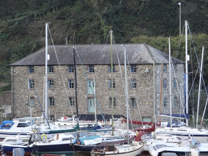
Mid to later C19 quayside warehouse, said to have been used for grain storage. Latterly used as sail training school. Not marked on 1844 tithe map but visible in photograph taken before bridge was rebuilt in 1875.
Former warehouse, rubble stone with slate hipped roof, formerly grouted. Substantial 4-storey, 6-window block, the rear built into the bank. Small windows mostly metal 6-pane, with red brick cambered heads and slate sills, the upper windows under eaves are smaller. On second floor, blocked loading door opening in third bay from right, on first floor door in similar position is infilled as a window. On ground floor, 4 windows, broad brick depressed-arched entry to left, and doorway to right, set out of alignment. End elevations of 2 bays each and both with window openings to upper floors only, all windows blocked on S end wall. Rear elevation has present access via C20 footbridge to loading door in right bay of second floor.
Interior subdivided on ground floor. Joisted ceilings with pine joists.
Included as a prominent C19 stone warehouse, the last indication of the scale of maritime traffic into Fishguard in the C19.
External links are from the relevant listing authority and, where applicable, Wikidata. Wikidata IDs may be related buildings as well as this specific building. If you want to add or update a link, you will need to do so by editing the Wikidata entry.


Other nearby listed buildings
