Approximate Location Map
Large Map »
Latitude: 51.9957 / 51°59'44"N
Longitude: -4.9683 / 4°58'5"W
OS Eastings: 196319
OS Northings: 237190
OS Grid: SM963371
Mapcode National: GBR CL.JDB4
Mapcode Global: VH1QM.T3TF
Plus Code: 9C3QX2WJ+7M
Entry Name: The Dinas Arms
Listing Date: 24 November 1978
Last Amended: 7 January 2002
Grade: II
Source: Cadw
Source ID: 12328
Building Class: Commercial
ID on this website: 300012328
Location: Situated on the street line, in the angle formed by the junction of Newport Road and Quay Street.
County: Pembrokeshire
Town: Fishguard
Community: Fishguard and Goodwick (Abergwaun ac Wdig)
Community: Fishguard and Goodwick
Locality: Lower Town
Traditional County: Pembrokeshire
Tagged with: Architectural structure
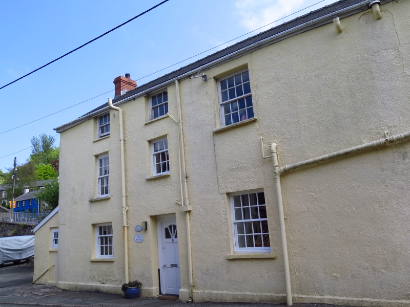
Former public house, prominently sited facing down narrow main road. Earlier C19, a building marked on the site on the 1844 tithe map. Since 1978 the facade has been altered, generally by removal of late C19 to earlier C20 alterations.
Former public house, rubble stone, 2 storeys with slate roof hipped to front rubble stone, exposed to first floor and clad in colourwashed roughcast to ground floor. On the first floor 2 large 18-pane sashes with rendered mullion between replace, since 1978, a triple sash window without glazing bars. Ground floor door to the left and large 20-pane sash to centre and right, replacing, since 1978, a late C19 to early C20 window to the right and a doorway to left hand, all in casing of pilasters, fascia and cornice. Against the NE side, to Newport Road, a complex of lean-to additions, first a lean-to of colourwashed stone rubble and slate roof, formerly cemented, with one small C20 window facing the front and one similar window each floor to the Newport Road. This is in angle to a larger outshut with a 5-pane C20 window each floor, and then to right is an outbuilding at right-angles with monopitch roof.
Quay Street elevation is of colourwashed roughcast, blank to right (the end of the front range), then large 16-pane sash each floor to centre (replacing C20 casement over 4-pane sash), while the right, with same eaves line is 3-storey, 2-window with small square 6-pane sashes under eaves, sash windows of different lengths to first floor 12-pane left, 9-pane right, and, on ground floor, a square 12-pane sash window to left and a C20 panelled door with shallow overlight to right.
Included on the list as a prominently sited earlier C19 building of townscape importance.
External links are from the relevant listing authority and, where applicable, Wikidata. Wikidata IDs may be related buildings as well as this specific building. If you want to add or update a link, you will need to do so by editing the Wikidata entry.


Other nearby listed buildings
