History in Structure

Telephone Call-box (01600 860389)

A Grade II Listed Building in Trellech United (Tryleg Unedig), Monmouthshire

More Photos »
Approximate Location Map
Large Map »

Coordinates

Latitude: 51.7556 / 51°45'20"N

Longitude: -2.6765 / 2°40'35"W

OS Eastings: 353397

OS Northings: 206540

OS Grid: SO533065

Mapcode National: GBR JM.0MF7

Mapcode Global: VH877.K4CH

Plus Code: 9C3VQ84F+69

Entry Name: Telephone Call-box (01600 860389)

Listing Date: 21 February 1994

Last Amended: 28 February 2001

Grade: II

Source: Cadw

Source ID: 14338

Building Class: Communications

ID on this website: 300014338

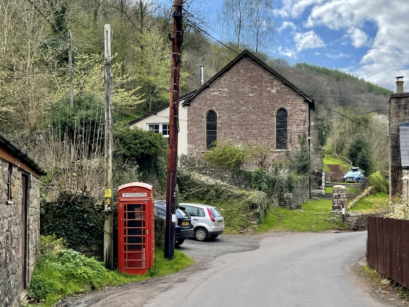
Location: Situated at the side of the narrow country lane that runs through the village of Whitebrook; opposite to Manor Brook Cottage and about 50m east of the Church of the Holy Trinity.

County: Monmouthshire

Town: Monmouth

Community: Trellech United (Tryleg Unedig)

Community: Trellech United

Locality: Whitebrook

Traditional County: Monmouthshire

Tagged with: Red telephone box

Find accommodation in
Llandogo

History

Telephone box of G VI R, K6-type. Standard design of Giles Gilbert Scott, architect of London; design introduced by the GPO in 1936 but not erected in the remote rural areas such as this until after WWII.

Exterior

Square, red kiosk of cast-iron construction. Domed roof with 4 lunettes containing embossed George VI crowns over red lettered opals and ventilation slits. Raised surrounds with marginal bars to horizontal glazing; moulded plinth. Blank rear. Foundry plate not visible.

Reasons for Listing

Included for its contribution to this rural Conservation Area and for its group value with the nearby Church of Holy Trinity and The Swan.

External Links

External links are from the relevant listing authority and, where applicable, Wikidata. Wikidata IDs may be related buildings as well as this specific building. If you want to add or update a link, you will need to do so by editing the Wikidata entry.

Recommended Books

Other nearby listed buildings

  • II The Bell
    On the south side of the road towards the eastern end of Whitebrook valley and about 100m east of the Church of the Holy Trinity.
  • II Church of the Holy Trinity
    On the south side of the road towards the eastern end of Whitebrook valley.
  • II Cider Mill at Fern Bank
    On the north side of the Whitebrook valley road and about 150m west of the Church of the Holy Trinity.
  • II Wye Valley Millhouse
    On the north side of the road towards the eastern end of Whitebrook valley and about 200m east of the Church of the Holy Trinity.
  • II Whitebrook Farmhouse
    At the eastern entrance to Whitebrook valley and about 400m east of the Church of the Holy Trinity.
  • II Chimney of former Clearwater Mill
    On the north side of the Whitebrook valley road and about 350m west of the Church of the Holy Trinity.
  • II Clearwater House
    On the north side of the Whitebrook valley road and about 450m west of the Church of the Holy Trinity.
  • II Pilstone Farmhouse
    Prominently sited across the slope on west side of the Wye Valley; Pilstone Farm is reached from the by-road that runs north from the main A466 where it crosses the river at Bigsweir Bridge. Approxima

BritishListedBuildings.co.uk is an independent online resource and is not associated with any government department. All government data published here is used under licence. Please do not contact BritishListedBuildings.co.uk for any queries related to any individual listed building, planning permission related to listed buildings or the listing process itself.

British Listed Buildings is a Good Stuff website.