Approximate Location Map
Large Map »
Latitude: 52.0571 / 52°3'25"N
Longitude: -4.6342 / 4°38'3"W
OS Eastings: 219498
OS Northings: 243135
OS Grid: SN194431
Mapcode National: GBR D0.DK6G
Mapcode Global: VH2MW.MKGC
Plus Code: 9C4Q3948+R8
Entry Name: Cilgerran Castle
Listing Date: 15 April 1994
Last Amended: 15 April 1994
Grade: I
Source: Cadw
Source ID: 14491
Building Class: Defence
ID on this website: 300014491
Location: Situated on a bluff where the Afon Plysgog joins the River Teifi.
County: Pembrokeshire
Community: Cilgerran
Community: Cilgerran
Built-Up Area: Cilgerran
Traditional County: Pembrokeshire
Tagged with: Castle
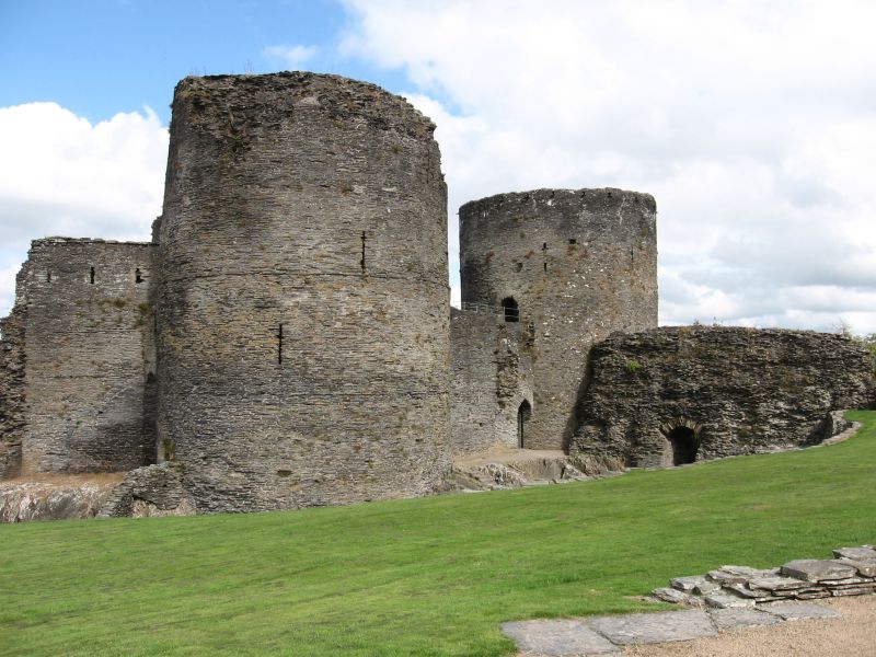
C13 Castle rebuilt after 1223 by William Marshal II, Earl of Pembroke, probably replacing an early C12 castle built by Gerald of Windsor; but the identification of Cilgerran with Gerald's castle of Cenarth Bychan is unproven. The castle named as Cilgerran is first mentioned when it was taken by Lord Rhys in 1164-5. It was retaken by William Marshal I, Earl of Pembroke in 1204, recovered by Llewellyn the Great in 1213, and retaken by William Marshal II in 1223. Cilgerran remained an independent Marcher lordship under the Marshals to 1245, the de Cantelupes of Abergavenny to 1273 and by descent to the Hastings family (Earls of Pembroke from 1339) to 1389, when it passed to the crown in default of heirs. It was possibly briefly captured by Owen Glyndwr in 1405.
The castle was already stripped of furnishings in 1275, and said to be ruinous in 1325, though some repairs were carried out for the Crown in 1388-90; it was said to have been laid waste in 1405.
The ruins chiefly surround the inner ward, with two massive early C13 circular towers on the S side joined by curtain wall. To the W was the early C13 gatehouse of which the outer part has gone. The chapel may have been on the first floor. The W curtain wall over the steep drop to the Afon Plysgog is said to date to the later C13, and the partial remains of a NW tower possibly to the later C14. Insubstantial remains close the N side, above the Teifi.
Scheduled Ancient Monument Pe 2.
External links are from the relevant listing authority and, where applicable, Wikidata. Wikidata IDs may be related buildings as well as this specific building. If you want to add or update a link, you will need to do so by editing the Wikidata entry.


Other nearby listed buildings
