Approximate Location Map
Large Map »
Latitude: 52.9653 / 52°57'55"N
Longitude: -2.9618 / 2°57'42"W
OS Eastings: 335499
OS Northings: 341318
OS Grid: SJ354413
Mapcode National: GBR 77.K717
Mapcode Global: WH89C.GQVK
Plus Code: 9C4VX28Q+47
Entry Name: The Boat Inn PH
Listing Date: 13 February 1995
Last Amended: 13 February 1995
Grade: II
Source: Cadw
Source ID: 15166
Building Class: Commercial
Also known as: The Boat, Wrexham
Boat
The Boat Inn Ph, Erbistock
ID on this website: 300015166
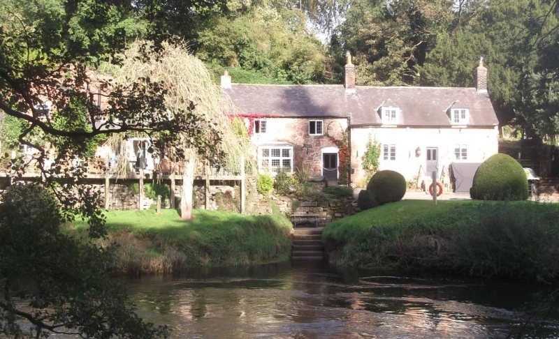
Formerly two buildings close to the site of a former ferry crossing on the River Dee, the Boat Inn was noted for its picturesque character and situation. The building appears to date from the C17 and has been remodelled in the C19 and late C20. It is now a public house and restaurant.
Sandstone rubble, slate roof, brick chimneys, extensions and repairs. Formerly 2 houses, that to the left 2-storey 2-window with a brick rebuilding visible at the eaves. Entrance on the right with a later door and bay window, upper floor windows are cast-iron multipaned casements. House to right is single-storey over basement with C19 dormers with hipped roofs to attic, dressed stone quoins. Steps up to central entrance, casement windows with cast-iron transoms, to left a low entrance to the basement. Rear has C19 and later C20 extensions.
This has been remodelled and the two houses converted into one. Ground floor rooms have heavy chamfered and stopped beams. There is a fireplace with bressumer in the right hand section and a C19 winding stair. Upper floor has partially exposed and altered roof truss.
Listed as a C17 building with C19 remodelling retaining some original features.
Group value with St. Hilary's Church.
External links are from the relevant listing authority and, where applicable, Wikidata. Wikidata IDs may be related buildings as well as this specific building. If you want to add or update a link, you will need to do so by editing the Wikidata entry.


Other nearby listed buildings
