Approximate Location Map
Large Map »
Latitude: 52.9658 / 52°57'56"N
Longitude: -2.9597 / 2°57'34"W
OS Eastings: 335640
OS Northings: 341371
OS Grid: SJ356413
Mapcode National: GBR 77.K1LM
Mapcode Global: WH89C.HQV6
Plus Code: 9C4VX28R+84
Entry Name: The Old Rectory
Listing Date: 13 February 1995
Last Amended: 13 February 1995
Grade: II
Source: Cadw
Source ID: 15168
Building Class: Domestic
ID on this website: 300015168
Location: Situated In Erbistock Village 75m NW of St. Hilary's Church, reached from a by-road running S off A528.
County: Wrexham
Community: Erbistock (Erbistog)
Community: Erbistock
Traditional County: Flintshire
Tagged with: Clergy house
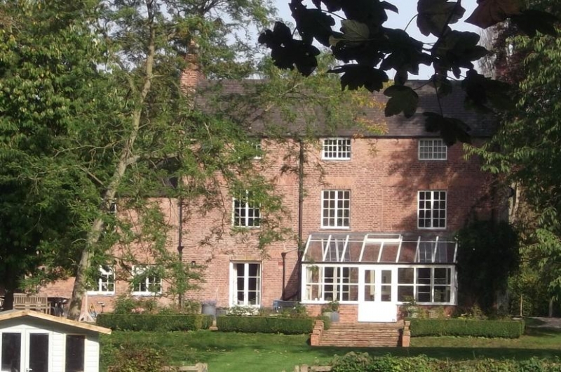
Mentioned in a Terrier of 1685 and the Bishop's Visitations of 1709. House of at least two building phases, first probably dating to late C17/early C18 followed by subsequent late C18 additions and mid C19 internally remodelling. At present sub-divided into two dwellings.
Late C18 3-storey 3-window, red brick garden front elevation in flemish bond with slate roof and gable brick stacks. Modern conservatory at ground floor level, one later window to left. First floor level exhibits considerable alteration of fenestration pattern, 3 sliding sash windows. Alterations probably date to a mid C19 remodelling of the property. Attic storey probably later addition, three 18-paned sliding sash windows. To left one and a half storey later extension. Rear elevation facing road: to right, late C17/early C18, 2- storey block which was the original building on the site. Probably red sandstone rubble, later refaced in red brick and pebbledashed, gable brick stacks, slate roof. Later door in original position. To centre of first floor small window with margin lights some of coloured glass. To left 2 storey canted bay, brick and sandstone rubble constuction. Originally single storey, with three open arches, now blocked and central arch filled by door. First floor two blind windows, one 16-pane sash window.
Interior not accessible at time of inspection (November 1994).
Listed as a late C17/early C18 building which despite later alterations and remodellings retains much of its character.
Group value with St. Hilary's Church.
External links are from the relevant listing authority and, where applicable, Wikidata. Wikidata IDs may be related buildings as well as this specific building. If you want to add or update a link, you will need to do so by editing the Wikidata entry.


Other nearby listed buildings
