History in Structure

Pont Terrig

A Grade II Listed Building in Nercwys, Flintshire

More Photos »
Approximate Location Map
Large Map »

Coordinates

Latitude: 53.1235 / 53°7'24"N

Longitude: -3.1366 / 3°8'11"W

OS Eastings: 324039

OS Northings: 359085

OS Grid: SJ240590

Mapcode National: GBR 70.76KS

Mapcode Global: WH77C.SRL9

Plus Code: 9C5R4VF7+C9

Entry Name: Pont Terrig

Listing Date: 12 December 1994

Last Amended: 12 December 1994

Grade: II

Source: Cadw

Source ID: 15246

Building Class: Transport

ID on this website: 300015246

Location: Road bridge over the River Terrig at the boundary between the Nercwys and Treuddyn Community Council areas.

County: Flintshire

Community: Nercwys

Community: Nercwys

Locality: Pentre

Traditional County: Flintshire

Tagged with: Bridge

Find accommodation in
Nerquis

History

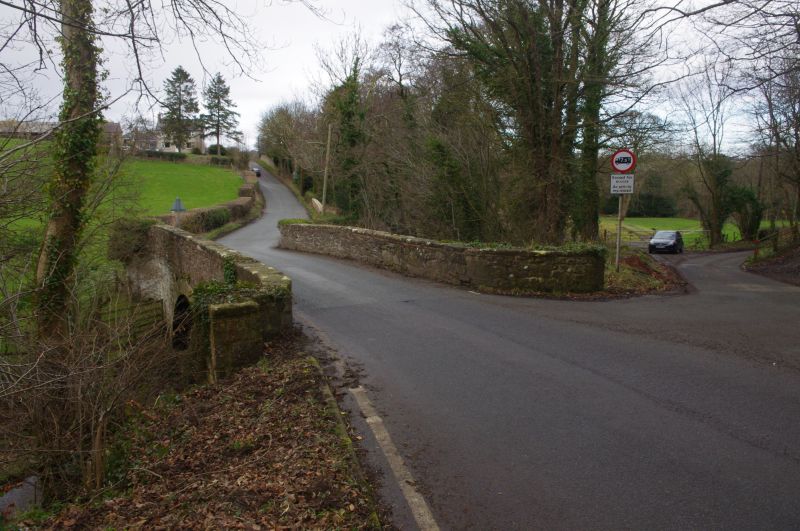
Late C18/early C19 single-span rubble bridge.

Exterior

Wide arch with projecting dressed stone voussoirs and a plain string-course. Stone coping to rubble parapets with swept returns on both sides, terminating in butresses. The parapet has C19 and early C20 incised drawings and graffiti.

Reasons for Listing

Included as a good well-proportioned period bridge.

External Links

External links are from the relevant listing authority and, where applicable, Wikidata. Wikidata IDs may be related buildings as well as this specific building. If you want to add or update a link, you will need to do so by editing the Wikidata entry.

Recommended Books

Other nearby listed buildings

  • II Glan Terrig Farmhouse
    To the SE of Nercwys village. Situated off Ffordd Nercwys to the E facing its own farmyard.
  • II Plas Nant y Glyn (excluding C20 W Range)
    Located at the end of a long track to the L of a lane leading off Ffordd Nercwys to the E, at the S extremity of the community council area.
  • II Stryt Swndwr
    Located on the north-west side of a lane which connects Ffordd Nercwys and Ffordd Carreg-y-Llech.
  • II Barn at Plas Ucha Farm
    Immediately to the W of the farmhouse forming the S side of the farmyard.
  • II Plas Ucha Farmhouse
    To the S of Nercwys village. Located on the S side of a lane leading off to the W at the lower end of Fordd Nercwys, and set back behind a dwarf-walled front garden.
  • II C18 Gates and Gate-Piers in the Garden at Nerquis Hall
    To the S of the House, at the end of the formal, yew-hedged lawn.
  • II Orangery at Nerquis Hall
    To the W of Nerquis Hall at the end of an orchard, and close to the road.
  • I Nerquis Hall
    To the E of a subsidiary road leading from Mold to Treuddyn, approached via a tree-lined drive and facing a large forecourt.

BritishListedBuildings.co.uk is an independent online resource and is not associated with any government department. All government data published here is used under licence. Please do not contact BritishListedBuildings.co.uk for any queries related to any individual listed building, planning permission related to listed buildings or the listing process itself.

British Listed Buildings is a Good Stuff website.