Latitude: 51.7743 / 51°46'27"N
Longitude: -3.089 / 3°5'20"W
OS Eastings: 324961
OS Northings: 208964
OS Grid: SO249089
Mapcode National: GBR F2.ZJD6
Mapcode Global: VH79C.DNVP
Plus Code: 9C3RQWF6+PC
Entry Name: The Beeches Nursing Home (formerly known as Ty Mawr)
Listing Date: 9 February 1995
Last Amended: 9 February 1995
Grade: II
Source: Cadw
Source ID: 15272
Building Class: Health and Welfare
ID on this website: 300015272
Location: Situated near the top of Church Road, set well back, in a walled garden.
County: Torfaen
Community: Blaenavon (Blaenafon)
Community: Blaenavon
Built-Up Area: Blaenavon
Traditional County: Monmouthshire
Tagged with: Architectural structure
Built around 1800 by Samuel Hopkins, son of the first resident manager of the Ironworks and himself proprietor from 1798. An 1839 date stone in the car park may refer to an additional building phase. The house was used by the directors of the Blaenavon Company as a hunting lodge until 1924. It was then converted into a hospital and became the local medical society, into which the workers paid a subscription, pre-empting the National Health Service.
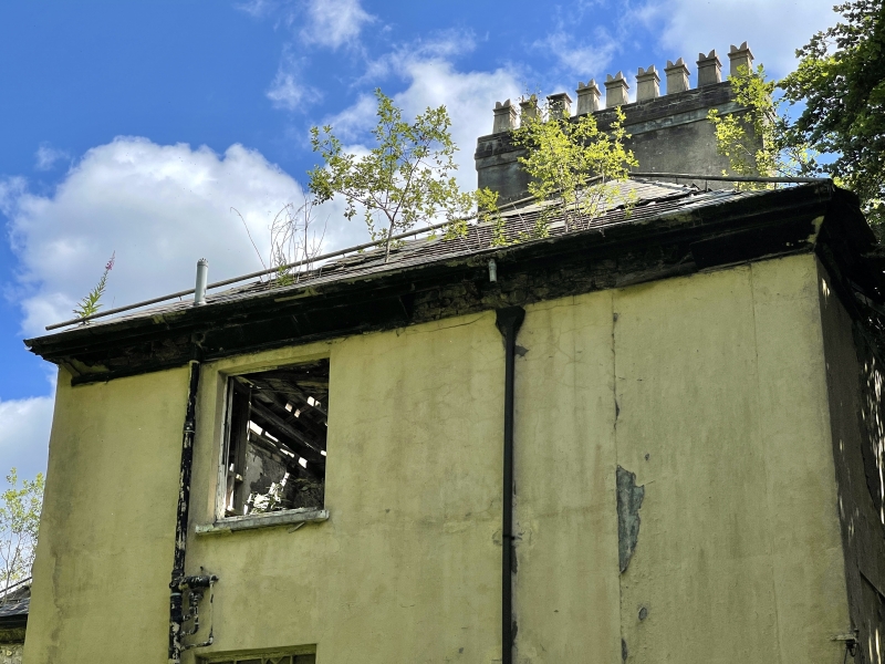
A late Georgian rendered three storey mansion. The original block is on a rectangular plan with extensions to rear. Small-pane sash windows. Six-bay main facade with plinth and band courses between floors. Wide doorway is flanked by pair of wooden pilasters standing on stone plinths. Door itself is modern. There are six ground floor windows of varying sizes, five are sash. One small window is probably a later insert. First floor has four sash windows, second floor has five. Cast iron fire escape stands against the facade presumably dating from its use as a hospital. Deep wooden eaves are of simple moulding. Hipped, M-shaped roof is of slate, with lead covering the ridge tiles. A large rendered chimney stack is at the north, with nine yellow ceramic chimney pots. To the south a rendered ashlar wall with lean-to roof is edged with a thin tapering stone column.
South elevation overlooks gardens and has at some time become the main entrance. It includes two later blocks added to the east, all with square headed sash windows. The original block has two bays on three storeys and a conservatory across its ground floor, with five cast iron columns. Adjoining this is a later block with three bays on two storeys and pitched slate roof. A further block is one storey with flat roof.
The interior has been much altered to accommodate the building's use as a nursing home, although the original room layouts are apparent from the surviving ceiling cornices. Two large reception rooms on the ground floor retain their grand fireplaces, one of which is of cast iron with fine detailing, painted to resemble carved marble. The main staircase is possibly original. A 1926 Smith Major and Stephens lift is original to the building's first hospital phase. The cellar has wall tiling incorporating a green cross, which is evidence of its use as a mortuary.
Listed as a late-Georgian building with special historical interest.
External links are from the relevant listing authority and, where applicable, Wikidata. Wikidata IDs may be related buildings as well as this specific building. If you want to add or update a link, you will need to do so by editing the Wikidata entry.


Other nearby listed buildings