History in Structure

Former Threshing Barn at Braich y Saint

A Grade II Listed Building in Criccieth (Cricieth), Gwynedd

More Photos »
Approximate Location Map
Large Map »

Coordinates

Latitude: 52.939 / 52°56'20"N

Longitude: -4.2172 / 4°13'1"W

OS Eastings: 251097

OS Northings: 340262

OS Grid: SH510402

Mapcode National: GBR 5L.LVD6

Mapcode Global: WH55K.6D26

Plus Code: 9C4QWQQM+J4

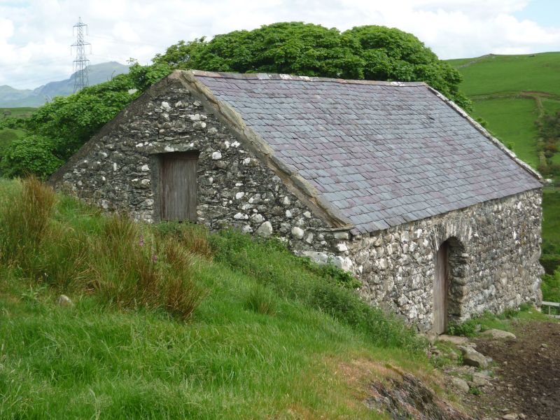
Entry Name: Former Threshing Barn at Braich y Saint

Listing Date: 12 December 1994

Last Amended: 12 December 1994

Grade: II

Source: Cadw

Source ID: 15378

Building Class: Agriculture and Subsistence

ID on this website: 300015378

Location: On the slope above and west of the farmhouse.

County: Gwynedd

Community: Criccieth (Cricieth)

Community: Criccieth

Traditional County: Caernarfonshire

Tagged with: Barn

Find accommodation in
Criccieth

History

Probably late C17.

Exterior

Random slate rubble, in which the gaps between the larger stones are filled in with smaller ones. Slate roof. Built against the slope, with opposed doors, each with steep rough voussoir arch. The space is unequally divided as 1-2 bays by the entrances. Single small vent in rear. Upper entry with rough timber lintel in the W gable wall. Slate threshing floor. Rough queen strutt trusses, with ridge and 2 purlins, set into the wall below the present wall plate.

Reasons for Listing

An excellent example of a late C17 threshing barn which survives virtually unaltered.

External Links

External links are from the relevant listing authority and, where applicable, Wikidata. Wikidata IDs may be related buildings as well as this specific building. If you want to add or update a link, you will need to do so by editing the Wikidata entry.

Recommended Books

Other nearby listed buildings

  • II Braich y Saint
    2km approx. NE of Criccieth, set back to the N of a lane running W from the N of Pentrefelin.
  • II Braich y Saint
    2km approx. NE of Criccieth, set back to the N of a lane running W from the N of Pentrefelin.
  • II Mynydd Ednyfed Fawr
    Towards the top of the lane approx. 1.5km out of Criccieth, below the golf club house.
  • II Mile Post
    Up against the stone field boundary wall, c100m NE of the drive leading to Mynydd Ddu.
  • II Cefn-y-meysydd isaf
    The house lies at the end of a farm road leading off the minor Pentrefelin to Dolbenmaen road, and N of Pentrefelin village.
  • II* Wash House
    Set back from the road 2km approx, to the E of the town, and 0.5km approx. Down a track.
  • II* Former Stables
    Set back from the road 2km approx, to the E of the town, and 0.5km approx. Down a track.
  • II* Ystumllyn
    Set back from the road 2km approx, to the E of the town, and 0.5km approx. Down a track.

BritishListedBuildings.co.uk is an independent online resource and is not associated with any government department. All government data published here is used under licence. Please do not contact BritishListedBuildings.co.uk for any queries related to any individual listed building, planning permission related to listed buildings or the listing process itself.

British Listed Buildings is a Good Stuff website.