Approximate Location Map
Large Map »
Latitude: 52.0451 / 52°2'42"N
Longitude: -3.2731 / 3°16'23"W
OS Eastings: 312787
OS Northings: 239290
OS Grid: SO127392
Mapcode National: GBR YV.F6RQ
Mapcode Global: VH6BG.7V0L
Plus Code: 9C4R2PWG+2Q
Entry Name: Church of St Cynog
Listing Date: 18 January 1996
Last Amended: 18 January 1996
Grade: II
Source: Cadw
Source ID: 17183
Building Class: Religious, Ritual and Funerary
ID on this website: 300017183
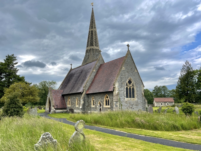
Location: The church is located near the centre of a large circular graveyard, at the centre of the small village of Boughrood.
County: Powys
Community: Glasbury (Y Clas-ar-wy)
Community: Glasbury
Locality: Boughrood
Traditional County: Radnorshire
Tagged with: Church building
The circular graveyard suggests an early site, but the present church was built in 1870 by C.H.Howell, in the manner of H.Woodyer, to replace an earlier building. The bold broach spire which completed the composition was reduced in height c. 1988 to reduce maintenance costs.
Grey snecked and squared sandstone rubble with limestone dressings, tiled roof the crested ridge between coped gables. Decorated Gothic style with late C13 style tracery. Nave with N aisle and S porch, large square tower on the N side, and chancel with a N vestry. Porch has sharply pointed outer arch set in steep coped gable, the roof extending down to approximately 1m above ground. Nook shafts and naturalistic vineleaf capitals. The nave has 2-light cusped windows with quatrefoil heads and a cusped lancet at the E end. The chancel has a S priest's door with foils in the arch. Two-light and lancet windows, similar to Nave. Three-light E window with cusped quatrefoil in wheel head. Two-light window to lean-to aisle and trefoiled lights to the vestry. The tower has western buttress, and an external door to the stair tower to the E the part-octagonal stair terminating in a low conical stone cap.
In the churchyard, approximately 27m S of S door, a sundial with octagonal shaft on a square base, and moulded capital of late C13 type, perhaps original, raised on 3 steps. Dial plate missing.
Door to the nave is boarded with decorative iron hinges, set in a wave-moulded surround dying out in the jambs. Nave is of 3 roof bays, lofty, with arch-braced collar trusses and long curved windbraces to the single tier of purlins. Open rafters and boarded soffit. The trusses spring from wall corbels with shafts and foliated capitals. Two-bay arcade on N, depressed chamfered arches on an octagonal column. Deeply carved naturalistic capitals, extending as a wall string to angels flanking the arched opening into the base of the tower. Narrow lean-to aisle roof. The chancel is narrower, raised 1 step. Colourwashed walls as nave, and roof similar, supported on angel corbels. Two steps into sanctuary. East window has colonnettes at angles of reveals.
Fittings: Pews C19. Part-octagonal stone pulpit, the bookrest supported by a praying angel corbel. Font an octagonal bowl with columns with pendants at the angles and gabled relief tracery to each face. One bell in tower said to be pre-reformation, inscribed ORA PRO NOBIS SANCTA THOMA
Monuments: Nave S wall, a limestone tablet to Henry and Thomasina de Winton, †1920, and 2 brasses to de Winton incumbents, and a Great War brass.
Included, despite loss of the spire, as a good example of a small Victorian village church.
External links are from the relevant listing authority and, where applicable, Wikidata. Wikidata IDs may be related buildings as well as this specific building. If you want to add or update a link, you will need to do so by editing the Wikidata entry.


Other nearby listed buildings
