Approximate Location Map
Large Map »
Latitude: 52.0445 / 52°2'40"N
Longitude: -3.2727 / 3°16'21"W
OS Eastings: 312810
OS Northings: 239222
OS Grid: SO128392
Mapcode National: GBR YV.F6V4
Mapcode Global: VH6BG.7W61
Plus Code: 9C4R2PVG+RW
Entry Name: Village Farmhouse
Listing Date: 18 January 1996
Last Amended: 18 January 1996
Grade: II
Source: Cadw
Source ID: 17185
Building Class: Domestic
ID on this website: 300017185
Location: Located on the SE side of the perimeter road around the circular graveyard of Boughrood Church, approximately 200m from the church building.
County: Powys
Community: Glasbury (Y Clas-ar-wy)
Community: Glasbury
Locality: Boughrood
Traditional County: Radnorshire
Tagged with: Farmhouse
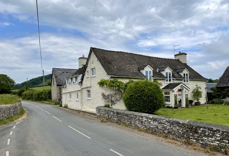
An early C17 timber-framed building later encased with stone, comprising a living room E of the cross passage, and two rooms to the W, the first a dairy. with a 2-bay rear service wing added, probably stone built from the start, with timber gables. The house was formerly held by the Haines family for more than 2 centuries, and was modernised shortly before 1970.
Colourwashed stone with tiled roofs. One storey and attic, 'L'-plan comprising a main 4-bay range set gable on to the road, and a 2-bay rear wing with gable stack added to the rear and set against the road, enclosing the farmyard in the angle. Central gabled porch. C19 6-paned sash windows and 3 raised gabled dormers close spaced at the centre. Gable stack. Rear range has battered stone walls and C20 fenestration to small openings on ground floor and a long raised window to the upper floor.
Main door leads to a cross passage formerly divided from the living room by a lightweight partition, now removed, the passage being within the 2 E bays. Two ovolo-moulded cross beams. Large gable stack with cupboard, perhaps originally a smoking chamber, to the right, and stone spiral stair on the left, having original small windows to gable and rear walls. The W half of the main range was originally two rooms, each with a central hollow-chamfered cross beam, jowled posts surviving on front and back walls. The rear wing, now the kitchen, has a gable stack with spiral stair to one side. Two chamfered cross beams. The roof consists of 4 trusses to the main range, having principals rising from stub ties carrying two tiers of purlins, and tenoned at the apex; not cruck as previously recorded. No smoke blackening. The roof of the rear wing has scissor laced gable against the main house, the roof now hipped in, and 2 tiers of purlins, the carpentry of lower quality.
Included as one of a good group of early buildings around the churchyard, and for the interior which retains high quality sub-medieval timber-framed construction.
External links are from the relevant listing authority and, where applicable, Wikidata. Wikidata IDs may be related buildings as well as this specific building. If you want to add or update a link, you will need to do so by editing the Wikidata entry.


Other nearby listed buildings
