History in Structure

Ty Capel Siloam

A Grade II Listed Building in Bontnewydd, Gwynedd

More Photos »
Approximate Location Map
Large Map »

Coordinates

Latitude: 53.1149 / 53°6'53"N

Longitude: -4.2679 / 4°16'4"W

OS Eastings: 248309

OS Northings: 359923

OS Grid: SH483599

Mapcode National: GBR 5J.7V01

Mapcode Global: WH43F.DYXY

Plus Code: 9C5Q4P7J+WR

Entry Name: Ty Capel Siloam

Listing Date: 29 July 1997

Last Amended: 29 July 1997

Grade: II

Source: Cadw

Source ID: 18613

Building Class: Religious, Ritual and Funerary

ID on this website: 300018613

Location: Situated on the E side of the A487 in Bontnewydd, just to the S of Capel Siloam and some 55m N of the bridge over the Afon Gwyrfai.

County: Gwynedd

Town: Caernarfon

Community: Bontnewydd

Community: Bontnewydd

Built-Up Area: Bontnewydd

Traditional County: Caernarfonshire

Tagged with: Architectural structure

Find accommodation in
Dinas

History

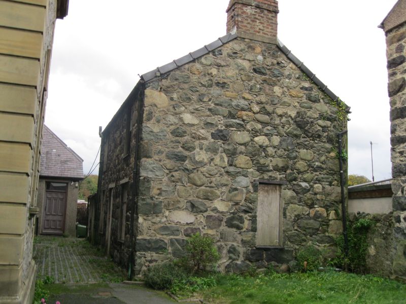
Mid to later C19 chapel house for Siloam Calvinistic Methodist Chapel.

Exterior

Coursed rubble stone with slate roof and stone end stacks with brick extensions. Rendered rear elevation. Two storeys, double-fronted with 12-pane horned sashes and centre door. Timber lintels to ground floor windows and doorway. Boarded door. One narrow sash window to W end and three windows to rear. E end has rendered single storey addition.

Reasons for Listing

Included for group value with Capel Siloam.

External Links

External links are from the relevant listing authority and, where applicable, Wikidata. Wikidata IDs may be related buildings as well as this specific building. If you want to add or update a link, you will need to do so by editing the Wikidata entry.

Recommended Books

Other nearby listed buildings

  • II Capel Siloam
    Situated on the E side of the A487 in Bontnewydd, some 70m N of the bridge over the Afon Gwyrfai.
  • II Newborough Arms
    Situated on the E side of the A487 in Bontnewydd, just N of the bridge over the Afon Gwyrfai.
  • II Arosfa
    Situated on the E side of the A487 in Bontnewydd, some 30m S of the bridge over the Afon Gwyrfai.
  • II Craigafon
    Situated on the E side of the A487 in Bontnewydd, some 140m S of the bridge over the Afon Gwyrfai.
  • II Pentre Uchaf
    Situated on the E side of the A487 in Bontnewydd, some 170m S of the bridge over the Afon Gwyrfai.
  • II Plas-y-bont
    Situated on the W side of the A487 in Bontnewydd, some 170m down a track S of the bridge over the Afon Gwyrfai.
  • II Nantlle Tramway River Bridge
    The Bridge spans Afon Gwyrfai on the west side of Bontnewydd.
  • II Bridge at Plas-y-bryn
    The bridge carries the road to Plas-y-Bryn over the Afon Gwyrfai some 400m E of the A487, SE of the centre of Bontnewydd.

BritishListedBuildings.co.uk is an independent online resource and is not associated with any government department. All government data published here is used under licence. Please do not contact BritishListedBuildings.co.uk for any queries related to any individual listed building, planning permission related to listed buildings or the listing process itself.

British Listed Buildings is a Good Stuff website.