Approximate Location Map
Large Map »
Latitude: 53.1146 / 53°6'52"N
Longitude: -4.2677 / 4°16'3"W
OS Eastings: 248318
OS Northings: 359892
OS Grid: SH483598
Mapcode National: GBR 5J.7V1F
Mapcode Global: WH43F.DZZ5
Plus Code: 9C5Q4P7J+RW
Entry Name: Newborough Arms
Listing Date: 29 July 1997
Last Amended: 29 July 1997
Grade: II
Source: Cadw
Source ID: 18614
Building Class: Commercial
ID on this website: 300018614
Location: Situated on the E side of the A487 in Bontnewydd, just N of the bridge over the Afon Gwyrfai.
County: Gwynedd
Town: Caernarfon
Community: Bontnewydd
Community: Bontnewydd
Built-Up Area: Bontnewydd
Traditional County: Caernarfonshire
Tagged with: Architectural structure
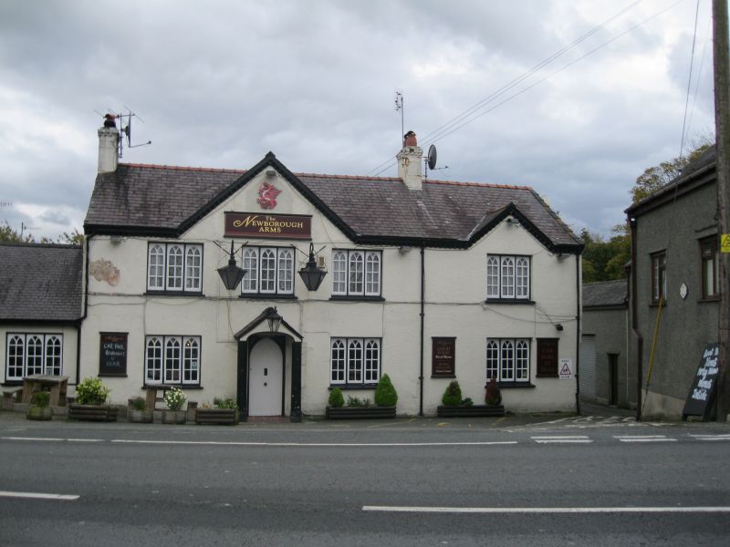
Early C19 coaching inn on main Caernarfon road, extended to right in C20. Marked as Newborough Arms on 1842 Llanbeblig Tithe Map of 1842 when it was a holding of some 11 acres (4.5ha), occupied by John Roberts and owned by Lord Newborough. Lord Newborough owned 284 (115ha) acres in the parish at this time.
Whitewashed roughcast with slate roof and red terracotta ridge. Rebuilt end stacks, rendered and whitewashed, the original S end stack now on ridge as building has been extended to S. Two-storey, three-window original range, one-window range added to right. Broad centre gable to original part, and small shallow gable to added section, carved scalloped eaves throughout. Windows are all flat-headed long triple casements, the lights small-paned with Gothic Y-tracery heads, slate sills. Centre half-glazed door in timber gabled shallow porch with cambered head. C20 small outbuilding with similar 3-light window added to left end wall. Large C20 rear extensions all with matching windows.
Included as a prominent early C19 coaching-inn on main turnpike road, still retaining distinctive gothic detailing.
External links are from the relevant listing authority and, where applicable, Wikidata. Wikidata IDs may be related buildings as well as this specific building. If you want to add or update a link, you will need to do so by editing the Wikidata entry.


Other nearby listed buildings
