History in Structure

St Elidy's Church Cross Base

A Grade II Listed Building in Amroth, Pembrokeshire

More Photos »
Approximate Location Map
Large Map »

Coordinates

Latitude: 51.7395 / 51°44'22"N

Longitude: -4.6618 / 4°39'42"W

OS Eastings: 216314

OS Northings: 207884

OS Grid: SN163078

Mapcode National: GBR GG.2GBW

Mapcode Global: VH2PF.4JVW

Plus Code: 9C3QP8QQ+Q7

Entry Name: St Elidy's Church Cross Base

Listing Date: 1 September 1997

Last Amended: 1 September 1997

Grade: II

Source: Cadw

Source ID: 18855

Building Class: Religious, Ritual and Funerary

ID on this website: 300018855

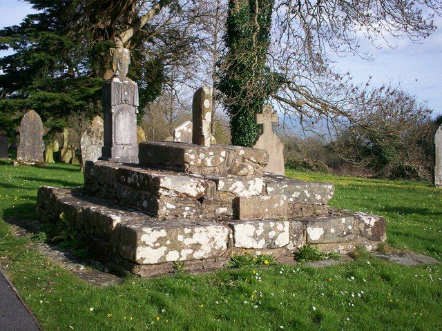
Location: Near the S porch of St Elidyr's Church, Amroth.

County: Pembrokeshire

Town: Tenby

Community: Amroth

Community: Amroth

Locality: Amroth Village

Traditional County: Pembrokeshire

Tagged with: Stone cross

Find accommodation in
Amroth

History

A mediaeval preaching cross base. Thomas Cromwell ordered the destruction of all preaching crosses in 1547, though many in S Pembrokeshire survived. This one was less fortunate. The present stone representing the cross shaft is a fragment of probably C17 window masonry.

Exterior

Four steps of local rubble masonry, much restored. A later stone erected to replace the cross.

Reasons for Listing

Listed as the fragmentaly survival of a medieval cross base, of group value with the church.

External Links

External links are from the relevant listing authority and, where applicable, Wikidata. Wikidata IDs may be related buildings as well as this specific building. If you want to add or update a link, you will need to do so by editing the Wikidata entry.

Recommended Books

Other nearby listed buildings

  • II* St Elidyr's Church
    1 km N of Amroth Village, in an isolated group with Amroth Farm and the old village school. The group is called 'Castle Back'. The church is in a roundish graveyard surrounded by walls and hedges.
  • II Former Sion House Gates (Lower pair)
    In the East Woods of Colby Woodland Gardens, on a woodland path close to the entrance to the gardens.
  • II Former Sion Gates (Upper pair)
    In the East Woods of Colby Woodland Gardens, on a woodland path close to the entrance to the gardens.
  • II Colby Lodge
    At the S side of a minor road ½ km NW of Amroth Church. The house is at the head of a valley in an extensive area of landscaped gardens and woodland in National Trust care.
  • I Amroth Castle
    At the N side of the unclassified coast road about ½ km E of the village of Amroth. A high wall screens the castle grounds from the road, with an entrance archway at the SW corner. A tree-lined drive
  • II Milestone on A477, in the verge south of Berryhillock
    Situated in the verge south of Berryhillock, on the W side of the A477.
  • II Milestone on A477, in the verge outside Pen-y-Bont Guest House
    Situated in the verge outside Pen-y-Bont guest house, on the N side of the A477.

BritishListedBuildings.co.uk is an independent online resource and is not associated with any government department. All government data published here is used under licence. Please do not contact BritishListedBuildings.co.uk for any queries related to any individual listed building, planning permission related to listed buildings or the listing process itself.

British Listed Buildings is a Good Stuff website.