History in Structure

The Black Lion Hotel

A Grade II Listed Building in Tal-y-bont, Ceredigion

More Photos »
Approximate Location Map
Large Map »

Coordinates

Latitude: 52.4841 / 52°29'2"N

Longitude: -3.9821 / 3°58'55"W

OS Eastings: 265498

OS Northings: 289205

OS Grid: SN654892

Mapcode National: GBR 8X.JL5L

Mapcode Global: VH4F0.XTNJ

Plus Code: 9C4RF2M9+M5

Entry Name: The Black Lion Hotel

Listing Date: 19 September 1997

Last Amended: 19 September 1997

Grade: II

Source: Cadw

Source ID: 18884

Building Class: Commercial

Also known as: Black Lion/Y Llew Du
Black Lion/Y Llew Du, Bow Street

ID on this website: 300018884

Location: Situated in centre of Talybont facing SW over the triangular green.

County: Ceredigion

Town: Aberystwyth

Community: Ceulanamaesmawr

Community: Ceulanamaesmawr

Locality: Talybont

Built-Up Area: Tal-y-bont

Traditional County: Cardiganshire

Tagged with: Hotel Pub

Find accommodation in
Talybont

History

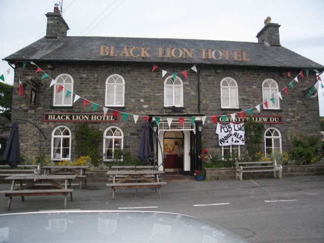
Mid C19 coaching inn, probably built after 1847 when Talybont Farmhouse, owned by the Gogerddan estate was marked on the Tithe Map on this site.

Exterior

Squared green-grey dolerite with slate eaves roof and stone end stacks, corniced in slate. Long two-storey, five-window front possibly remodelled from earlier building, as right two windows are closer spaced and there is some different stonework in the lower angles. Paired brackets to eaves. Round arched windows with stone voussoirs, slate sills and casement-pair glazing with fixed Y-tracery fanlights. Centre half-glazed door, Y-tracery fanlight in porch on 4 timber octagonal posts with simple corniced flat top. Glazed panels between post heads. Right end wall has 12-pane first floor sash with brick head. Rear has 12-pane sashes to right and added extension to left.

Reasons for Listing

A substantial coaching inn within a picturesque C19 facade, unusual in the overall use of arched openings.

External Links

External links are from the relevant listing authority and, where applicable, Wikidata. Wikidata IDs may be related buildings as well as this specific building. If you want to add or update a link, you will need to do so by editing the Wikidata entry.

Recommended Books

Other nearby listed buildings

  • II No 1 Tyrrel Place
    Situated in terrace of four houses, Nos 1-3 Tyrrel Place and Tyrrel House, just S of filling-station in Talybont.
  • II No 2 Tyrrel Place
    Situated in terrace of four houses, Nos 1-3 Tyrrel Place and Tyrrel House, just S of filling-station in Talybont.
  • II No 3 Tyrrel Place
    Situated in terrace of four houses, Nos 1-3 Tyrrel Place and Tyrrel House, just S of filling-station in Talybont.
  • II Tyrrel House
    Situated in terrace of four houses, Nos 1-3 Tyrrel Place and Tyrrel House, just S of filling-station in Talybont.
  • II* Ceulan Mills
    Situated behind houses on main road, on W bank of Ceulan, approached through grounds of Glenydd and Wern.
  • II NE range, Middle Factory, Leri Mills
    Situated on S bank of the Leri, some 150m W of Talybont Bridge, at upper end of mill complex.
  • II Upper Building, Middle Factory, Leri Mills
    Building parallel to track in mill group on S bank of Leri, some 170m W of Talybont Bridge
  • II Riverside Building, Middle Factory, Leri Mills
    Building parallel to riverbank in mill group on S bank of Leri, some 170m W of Talybont Bridge.

BritishListedBuildings.co.uk is an independent online resource and is not associated with any government department. All government data published here is used under licence. Please do not contact BritishListedBuildings.co.uk for any queries related to any individual listed building, planning permission related to listed buildings or the listing process itself.

British Listed Buildings is a Good Stuff website.