Approximate Location Map
Large Map »
Latitude: 51.5048 / 51°30'17"N
Longitude: -3.5326 / 3°31'57"W
OS Eastings: 293726
OS Northings: 179540
OS Grid: SS937795
Mapcode National: GBR HG.JG4M
Mapcode Global: VH5HK.QFBS
Plus Code: 9C3RGF38+WX
Entry Name: Brynffrwd Entrance and Lodge
Listing Date: 15 October 1997
Last Amended: 15 October 1997
Grade: II
Source: Cadw
Source ID: 18970
Building Class: Domestic
ID on this website: 300018970
Location: On the main village thoroughfare, W of the church, the stream of Nant Brynglas flowing alongside.
County: Bridgend
Community: Coychurch Lower (Llangrallo Isaf)
Community: Coychurch Lower
Locality: Coychurch
Built-Up Area: Bridgend
Traditional County: Glamorgan
Tagged with: Gatehouse
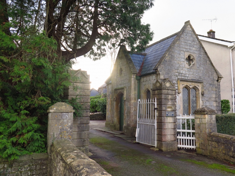
Lodge dated 1863 appears to be contemporary with Brynffrwd house, which does not appear on Tithe Map of 1841 or 1861 census, but appears by 1871 and is on first edition OS map of 1877. Bridge, walls and gateway also appear to be part of the original entrance design. Grounds were originally larger and roadside boundary was defined by decorative bridges, one of which adjacent to main bridge is included, the other, still extant, is separated by modern infill development.
Lodge is a small single one and a half storey gatehouse in Gothic Revival style on right of entrance. Built of coursed dressed stone, rendered to rear, with Welsh slate roof, ashlar coping with dogtooth finials, ridge and kneelers; rear chimney. Plan of rectangular wing with opposing cross gables, higher and deeper to right. Windows are pointed slightly ogee shaped lancets with diamond quarries and opening lights, paired to sides, under hood moulds; quatrefoils in gables. Cross gable left forms front entrance with square headed hood mould and heavy foliage stops, ogee arched doorway and diagonally boarded door; datestone in gable.
Entrance comprises gatepiers, gates, drive bridge and decorative boundary bridge.
Tall gatepiers are of deeply channelled ashlar with cross gabled capstones; the decorative wooden gates with iron panels are swept to matching height; small wicket gate to lodge right. Drive bridge is of coursed stone, double arched over the stream with low parapet with ashlar saddleback coping on either side, curved to roadside and ending in piers with capstones adjacent to the main gates. Boundary bridge across stream is a wall of two segmental arches with central pier, only one course wide and with rough stone coping.
Included together with separately listed house as an almost intact domestic complex of 1860s, with interesting contrast in styles and depicting contemporary social aspirations.
External links are from the relevant listing authority and, where applicable, Wikidata. Wikidata IDs may be related buildings as well as this specific building. If you want to add or update a link, you will need to do so by editing the Wikidata entry.


Other nearby listed buildings
