Approximate Location Map
Large Map »
Latitude: 51.8482 / 51°50'53"N
Longitude: -2.9582 / 2°57'29"W
OS Eastings: 334088
OS Northings: 217052
OS Grid: SO340170
Mapcode National: GBR F8.TLV5
Mapcode Global: VH791.NTY2
Plus Code: 9C3VR2XR+7P
Entry Name: Cross in Churchyard of Church of St David.
Listing Date: 5 February 1998
Last Amended: 5 February 1998
Grade: II
Source: Cadw
Source ID: 19314
Building Class: Religious, Ritual and Funerary
ID on this website: 300019314
Location: About 10m south of Church of St David.
County: Monmouthshire
Town: Abergavenny
Community: Llantilio Pertholey (Llandeilo Bertholau)
Community: Llantilio Pertholey
Locality: Llanddewi-Skirrid
Traditional County: Monmouthshire
Tagged with: Christian cross
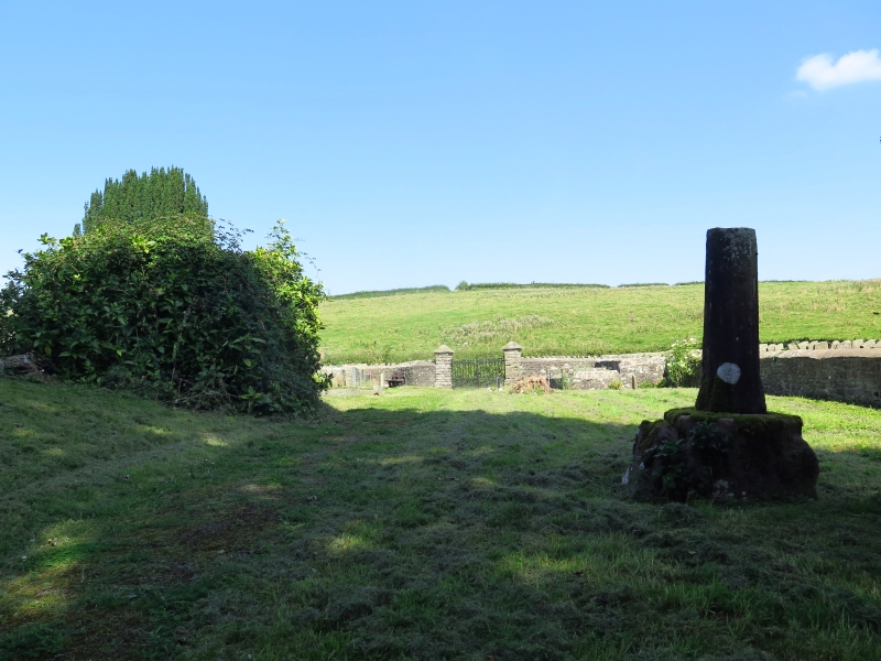
Late medieval, probably C15, churchyard cross now broken and fragmentary.
Sandstone. The socket stone rests directly on the ground as far as can be seen. It is square/octagonal with incised stops, but very worn, probably broached (otherwise bull-nosed). The shaft rises approximately 1m and is broken off; octagonal with pyramid stops to the base. A wheel-head cross is broken off and rests beside the shaft. This is of the same stone but may not be from the same cross.
Included as an example of a medieval churchyard cross which also has group value with the Church of St David.
External links are from the relevant listing authority and, where applicable, Wikidata. Wikidata IDs may be related buildings as well as this specific building. If you want to add or update a link, you will need to do so by editing the Wikidata entry.


Other nearby listed buildings
