Latitude: 53.0862 / 53°5'10"N
Longitude: -3.0659 / 3°3'57"W
OS Eastings: 328702
OS Northings: 354864
OS Grid: SJ287548
Mapcode National: GBR 72.9RR2
Mapcode Global: WH77L.WP6D
Plus Code: 9C5R3WPM+FJ
Entry Name: Ffrith Hall
Listing Date: 23 February 1998
Last Amended: 23 February 1998
Grade: II
Source: Cadw
Source ID: 19385
Building Class: Domestic
ID on this website: 300019385
Location: Prominently sited at the end of a short drive running W from the B5101 c0.5km S of Ffrith village.
County: Flintshire
Community: Llanfynydd
Community: Llanfynydd
Locality: Ffrith
Traditional County: Denbighshire
Tagged with: Architectural structure
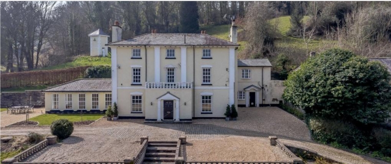
Probably constructed late C18. The porch was probably added at a later date.
Late Georgian villa; stucco, slate roof with wide boarded eaves, stuccoed chimneys, 3 storeys. Principal front to road is symmetrical and the elevation is articulated about four full-height pilasters, one at each end and two flanking central windows and probably the original entrance. There are 3 equally spaced sash windows per floor, those on the top floor with 6 panes the remainder having 12 panes. The centrally placed flat-roofed porch is balustraded and has a central pedimented entrance. Full exterior inspection not possible at time of 1997 survey and interior not accessible.
Listed as a good example of a late Georgian villa.
External links are from the relevant listing authority and, where applicable, Wikidata. Wikidata IDs may be related buildings as well as this specific building. If you want to add or update a link, you will need to do so by editing the Wikidata entry.


Other nearby listed buildings