History in Structure

Ffrith Bridge

A Grade II Listed Building in Llanfynydd, Flintshire

More Photos »
Approximate Location Map
Large Map »

Coordinates

Latitude: 53.0904 / 53°5'25"N

Longitude: -3.067 / 3°4'1"W

OS Eastings: 328637

OS Northings: 355334

OS Grid: SJ286553

Mapcode National: GBR 72.9CGZ

Mapcode Global: WH77L.VLP5

Plus Code: 9C5R3WRM+55

Entry Name: Ffrith Bridge

Listing Date: 2 July 1962

Last Amended: 23 February 1998

Grade: II

Source: Cadw

Source ID: 19387

Building Class: Transport

ID on this website: 300019387

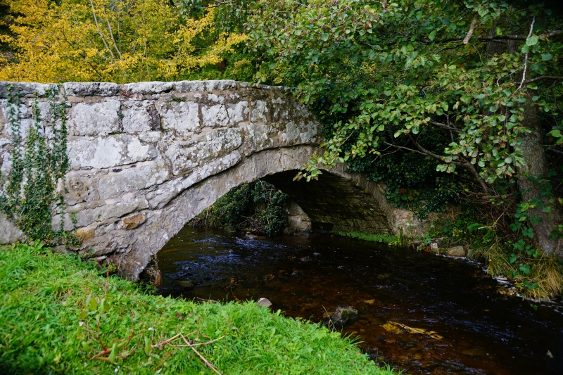
Location: Situated on the E side of Ffrith at the point at which Cymau Road becomes a track, the bridge carries the road over the River Cedigog.

County: Flintshire

Community: Llanfynydd

Community: Llanfynydd

Locality: Ffrith

Traditional County: Flintshire

Tagged with: Bridge Packhorse bridge

Find accommodation in
Ffrith

History

Said to be a packhorse bridge, probably of C18 date perhaps with earlier origins.

Exterior

Roughly squared and coursed rubble with a parapet of flat stones. The single-span bridge is skewed and is attached to a stone wall which runs along the N side of Cymau Road on the W side of the bridge, and to a stone wall running along the N side of the river on the E side. The SE side of the bridge terminates with a stone pier.

Reasons for Listing

Listed as a good example of a C18 skewed stone bridge.

Scheduled Ancient Monument No. F132.

External Links

External links are from the relevant listing authority and, where applicable, Wikidata. Wikidata IDs may be related buildings as well as this specific building. If you want to add or update a link, you will need to do so by editing the Wikidata entry.

Recommended Books

Other nearby listed buildings

  • II Pont Newydd y Ffrith
    Situated on the S side of Ffrith carrying the B5101 over the Nant y Ffrith.
  • II Ffrith Farmhouse
    Situated on the SW side of Ffrith, reached from a track running W from the B5101.
  • II Ffrith Hall
    Prominently sited at the end of a short drive running W from the B5101 c0.5km S of Ffrith village.
  • II Pair of Lime Kilns at Ffrith Quarry
    Situated c0.75km from Ffrith reached from footpaths leading SW from the B5101.
  • II Trimley Hall Barn
    Situated a short distance uphill (SW) from Trimley Hall and set into the slope
  • II* Trimley Hall
    Situated c1km NW of Ffrith, reached from a series of by-roads running W from the B5101.
  • II Church of Saint Mary
    On the N side of Brymbo.
  • II The Bottle Chimney
    Occupies an elevated site to the E of the Brymbo Lead Smelting Works site, between the reservoir and the Minera Road.

BritishListedBuildings.co.uk is an independent online resource and is not associated with any government department. All government data published here is used under licence. Please do not contact BritishListedBuildings.co.uk for any queries related to any individual listed building, planning permission related to listed buildings or the listing process itself.

British Listed Buildings is a Good Stuff website.