History in Structure

War Memorial

A Grade II Listed Building in Llanfair Pwllgwyngyll, Isle of Anglesey

More Photos »
Approximate Location Map
Large Map »

Coordinates

Latitude: 53.2213 / 53°13'16"N

Longitude: -4.2091 / 4°12'32"W

OS Eastings: 252608

OS Northings: 371635

OS Grid: SH526716

Mapcode National: GBR 5L.140C

Mapcode Global: WH546.99XB

Plus Code: 9C5Q6QCR+G9

Entry Name: War Memorial

Listing Date: 21 April 1998

Last Amended: 21 April 1998

Grade: II

Source: Cadw

Source ID: 19662

Building Class: Commemorative

ID on this website: 300019662

Location: In a prominent location in the centre of the village, at the edge of the car park of James Pringles, S side of Holyhead Road.

County: Isle of Anglesey

Town: Llanfairpwllgwyngyll

Community: Llanfair Pwllgwyngyll

Community: Llanfair Pwllgwyngyll

Locality: Llanfairpwllgwyngyll

Built-Up Area: Llanfair Pwllgwyngyll

Tagged with: War memorial

Find accommodation in
Llanfairpwllgwyngyll

History

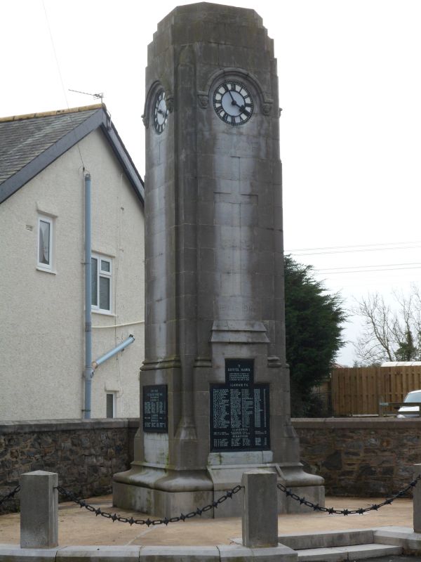
War memorial, probably c.1920.

Exterior

A columnary Cenotaph of ashlar limestone masonry in austere Classical style. The memorial is square in plan with a moulded plinth and stepped top. Each face has an advanced panel containing a clock in the upper part with moulded hood and carved head stops and an inset bronze tablet in the lower part inscribed with the names of the men of the parish who lost their lives in the 1914 - 1918 and 1939 - 1945 World Wars. The NW panel has a plain incised cross.

Reasons for Listing

Included as a good example of a Cenotaph in the Classical style, prominently sited and forming part of the townscape of Llanfairpwll.

External Links

External links are from the relevant listing authority and, where applicable, Wikidata. Wikidata IDs may be related buildings as well as this specific building. If you want to add or update a link, you will need to do so by editing the Wikidata entry.

Recommended Books

Other nearby listed buildings

  • II Telford Milestone
    In the centre of Llanfairpwll, set into the wall outside Ty Coch, on the N side of Holyhead Road, opposite Ty Gwyn Public House.
  • II Rhos y Gad Chapel and schoolrooms.
    In a conspicuous location on the NW side of Ffordd Penmynydd, close to the centre of the village.
  • II Tregarne
    Sited on the S side of A4080(T) Holyhead Road, close to the centre of the village, SW of the junior school.
  • II* Aberbraint
    Set back from the road within grounds on the NW side of the A4080 Brynsiencyn Road, c.0.5km from the Llanfairpwll Toll House.
  • II Aberbraint Lodge
    Located on the NW side of the A4080 Brynsiencyn Road, c. 0.5km from the Llanfair Toll House.
  • II Pen yr Allt
    Located on the NW side of the A4080 - Brynsiencyn Road, opposite the Grand Lodge to Plas Newydd.
  • II Entrance Archways, at Grand Lodge, Plas Newydd
    The N entrance to Plas Newydd, 1.7km N of the house, leading off the S side of the A4080 Brynsiencyn Road.
  • II Grand Lodge of Plas Newydd
    Set back slightly on the S side of the A4080 Brynsiencyn Road, behind the walls of Plas Newydd and at the entrance to the Grand Drive.

BritishListedBuildings.co.uk is an independent online resource and is not associated with any government department. All government data published here is used under licence. Please do not contact BritishListedBuildings.co.uk for any queries related to any individual listed building, planning permission related to listed buildings or the listing process itself.

British Listed Buildings is a Good Stuff website.