Approximate Location Map
Large Map »
Latitude: 52.9808 / 52°58'50"N
Longitude: -3.1991 / 3°11'56"W
OS Eastings: 319589
OS Northings: 343279
OS Grid: SJ195432
Mapcode National: GBR 6X.J9DB
Mapcode Global: WH783.TBTP
Plus Code: 9C4RXRJ2+89
Entry Name: Horseshoe Falls and canal entry pounds with sluices (partly in Llangollen Community)
Listing Date: 22 December 1989
Last Amended: 22 April 1998
Grade: II
Source: Cadw
Source ID: 19684
Building Class: Transport
ID on this website: 300019684
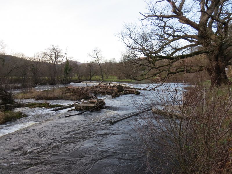
Location: The 'Falls' are located above rapids on the River Dee approximately 2km above Llangollen.
County: Denbighshire
Town: Llangollen
Community: Llantysilio
Community: Llantysilio
Locality: Pentrefelin
Traditional County: Denbighshire
The 'falls' are a near-crescent shaped weir placed in the abraided bed of the River Dee at a sharp bend above rapids, originally promoted by William Jessop, engineer to the Ellesmere Canal Company, in 1795, and constructed by Thomas Telford, chief engineer from 1804 to 1806 to impound water to feed, via sluices, into the head of the Llangollen Branch of the canal system. The width of the river bed provided an adequate reservoir, and was itself controlled at distance by sluices on the headwaters of the river at Llyn Tegid as originally proposed by Jessop in his report of 17th July 1795. The 6 mile (3.73 km) long Llangollen canal had been proposed as water feeder to the main Ellesmere Canal that was to link the Rivers Mersey and Dee with the River Severn. The Act was passed in 1793 and this upper section was constructed under the direction of Thomas Telford: work on the extension to Llantysilio was begun in 1804 and completed in 1806. The canal also provided transport for materials from the slate quarries and limestone works. In 1846 it became part of the Shropshire Union Railways and Canal Company but the following year was taken over by the LNWR. Transport on the canal diminished in later C19 with the arrival of the railways and then ceased by 2nd World War. The canal was only kept open because of its importance as a supplier of water; over 6 million gallons (13200 Litres) a day are metered into the canal at the Horseshoe Falls. The crescentic pattern adopted by Jessop had been previously used by his former tutor James Smeaton in 1776 at Acklington Mill, Northumberland; the 'falls' is considerably larger, at approx 54m radius.
The crescentic shaped weir is built of stone, 140.2m long with an upstream slope and a vertical downstream face of approximately 1.2m. The crest is of 1.2m square stones with a capping of bullnosed cast iron sections in 2.75m lengths. The course of the river on the E side above the weir is extended to a stone lined pound with sluices before entering the canal. A gauging station has more recently been located above the junction at the head of the canal.
Included as a fine early C19 weir, part of one of the earliest river regulation schemes carried out in Britain, and of group value with other listed structures on the Llangollen Canal.
External links are from the relevant listing authority and, where applicable, Wikidata. Wikidata IDs may be related buildings as well as this specific building. If you want to add or update a link, you will need to do so by editing the Wikidata entry.


Other nearby listed buildings
