Approximate Location Map
Large Map »
Latitude: 52.9941 / 52°59'38"N
Longitude: -2.8757 / 2°52'32"W
OS Eastings: 341321
OS Northings: 344441
OS Grid: SJ413444
Mapcode National: GBR 7B.HHYQ
Mapcode Global: WH89D.S0TH
Plus Code: 9C4VX4VF+JP
Entry Name: Emral Hall Lodge
Listing Date: 7 May 1998
Last Amended: 7 May 1998
Grade: II
Source: Cadw
Source ID: 19771
Building Class: Domestic
ID on this website: 300019771
Location: Located approximately 1 km north-east of Holly Bush Corner (A 525), to the east side of, and set back from, the lane.
County: Wrexham
Town: Wrexham
Community: Willington Worthenbury
Community: Willington Worthenbury
Locality: Emral
Traditional County: Flintshire
Tagged with: Gatehouse
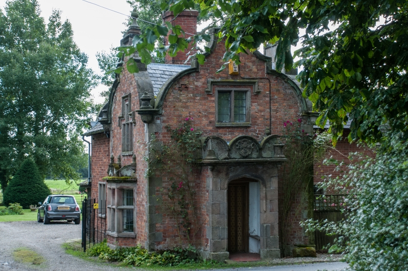
One of three Lodges to Emral Hall (demolished 1936); one of the other lodges has been demolished and the third altered. Possible C18 origins but the dominant character is C19. Said to have initially been re-modelled at the time of Richard Puleston's ascendancy to the Baronetcy in 1813. Sold as one of twenty-eight lots of the former Emral Hall estate of Crawshaw Wellington Puleston to Mr J Broad in 1916. Extension dated 1991.
Two storey red brick with stone dressings under slate roof. L-plan. Building constructed in three phases, original phase of C18 is square two-storey lodge with heavy stone quoins on stone base, with open porch to south elevation with heavy stone quoins and four-centred arched opening to C19 nailed door. Distinctive Flemish gables with stone copings. Rectangular stone mullioned windows under stone drip-moulds to first floor. Two-light square-paned leaded window to south and east, three-light square-paned leaded window to the west, the central light of which is stepped-up. Stone mullioned and transomed splayed bay window beneath. East window to ground floor is two-light with mullion and transom. At corners of C18 lodge heavy stone finials and pendentives with foliage carving to pendentive. Early/mid C19 extension to north with two-light square-paned leaded stone mullioned window to ground floor, fronted with pointed Flemish gable containing three-light stone mullioned window. Carved decorative stone enrichment added C19 ie stone finials to top of gables, semi-circular pediment to bay window, and porch. The parapet to the porch retains the Puleston coat-of-arms. To the east a two-storey extension of 1991 with date stone inscribed "EPB 1991" set in Flemish-style gable with stone finial under yellow brick coping.
Listed as a good example of a Jacobethan style estate lodge, for historic association with Emral Hall and group value with other listed items at Emral Hall.
External links are from the relevant listing authority and, where applicable, Wikidata. Wikidata IDs may be related buildings as well as this specific building. If you want to add or update a link, you will need to do so by editing the Wikidata entry.


Other nearby listed buildings
