Approximate Location Map
Large Map »
Latitude: 52.9633 / 52°57'47"N
Longitude: -3.0881 / 3°5'17"W
OS Eastings: 327012
OS Northings: 341211
OS Grid: SJ270412
Mapcode National: GBR 72.K6CV
Mapcode Global: WH785.JSP4
Plus Code: 9C4RXW76+8Q
Entry Name: Former Mount Zion Primitive Methodist Chapel and Graveyard
Listing Date: 11 June 1998
Last Amended: 11 June 1998
Grade: II
Source: Cadw
Source ID: 19960
Building Class: Religious, Ritual and Funerary
Also known as: Mount Zion
ID on this website: 300019960
Location: Situated next to school and stands within small graveyard on hill south of A5 road.
County: Wrexham
Town: Llangollen
Community: Llangollen Rural (Llangollen Wledig)
Community: Llangollen Rural
Locality: Froncysyllte
Built-Up Area: Froncysyllte
Traditional County: Denbighshire
Tagged with: Chapel
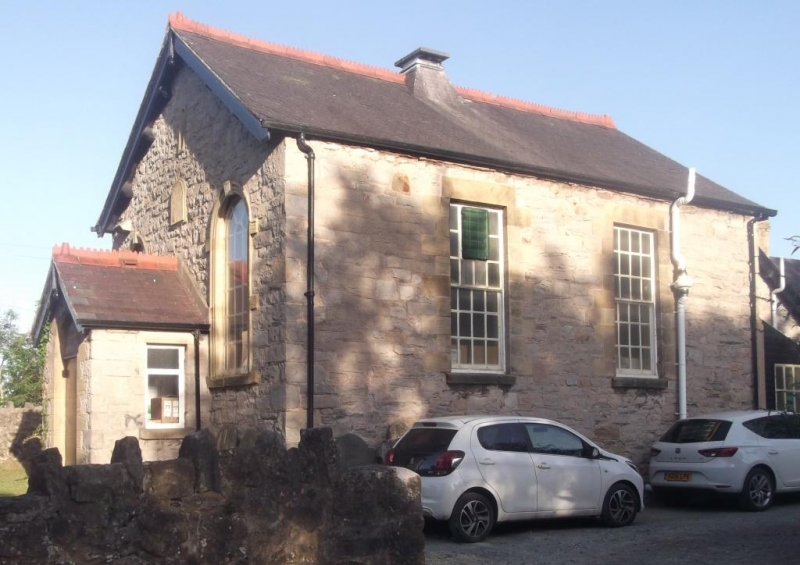
Small nonconformist chapel erected c1858 on land which had been acquired by the trustees of the proposed chapel in the same year. Subsequent to building a new Primitive Methodist chapel in 1914 on the main road (opposite St David's Church) Mount Zion was used as an additional classroom for the adjoining school (built 1863). Chapel is now used as school refectory.
Roughly squared limestone walls with sandstone door and window surrounds, slate roof with terra-cotta ridge cresting. Single storey gable front with central stone porch with round-headed doorway and blocked fanlight, tall round-headed windows with key-blocked arches on either side and small name plaque above porch, now very eroded with only the word 'Chapel' and 'M...' discernible. Modern, plain wood door. Side elevations each with two tall square-headed 24-pane sash windows. Mid-ridge, slate-covered vent.
Wood panelled dado. Coloured glass marginal panes to front windows. Flat ceiling with embossed decorative pattern, narrow coving and central vent outlet.
Listed as the earliest surviving chapel in the locality and a good example of traditional nonconformist architecture.
External links are from the relevant listing authority and, where applicable, Wikidata. Wikidata IDs may be related buildings as well as this specific building. If you want to add or update a link, you will need to do so by editing the Wikidata entry.


Other nearby listed buildings
