History in Structure

Sundial in the E Garden

A Grade II Listed Building in Chirk, Wrexham

More Photos »
Approximate Location Map
Large Map »

Coordinates

Latitude: 52.9347 / 52°56'4"N

Longitude: -3.0892 / 3°5'20"W

OS Eastings: 326891

OS Northings: 338034

OS Grid: SJ268380

Mapcode National: GBR 72.M045

Mapcode Global: WH78C.JH6J

Plus Code: 9C4RWWM6+V8

Entry Name: Sundial in the E Garden

Listing Date: 29 July 1998

Last Amended: 29 July 1998

Grade: II

Source: Cadw

Source ID: 20238

Building Class: Gardens, Parks and Urban Spaces

ID on this website: 300020238

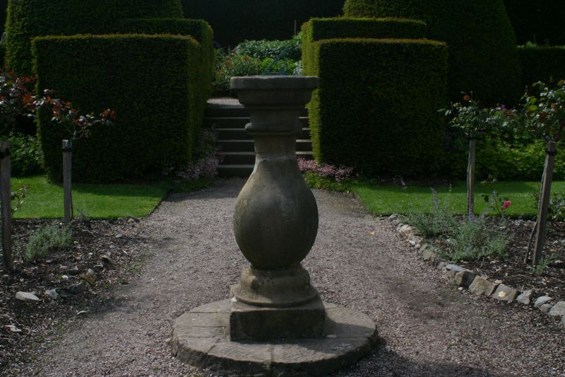
Location: The sundial is set in a pathway between the privy garden and the main top cross walk of the Eastern gardens of the Castle.

County: Wrexham

Town: Wrexham

Community: Chirk (Y Waun)

Community: Chirk

Locality: Chirk Castle

Traditional County: Denbighshire

Tagged with: Sundial

Find accommodation in
Chirk

History

Probably one of the sundials recorded as having been made for the gardens in the C17 by William Probert, who, in 1696, was paid fifteen shillings 'for a pillar of ffreestone pedistall & broad stone to sett the diall in the Castle garden'.

Exterior

A bold baluster shaft of stone with a necking ring and round ogee-moulded capital carrying a bronze plate and gnomon inscribed I MARK ONLY THE SHINING HOURS. The shaft stands on a moulded foot and is set on a circular slabbed stone platform.

Reasons for Listing

Included as an early example of a baluster sundial, which became a favoured garden ornament in the C18; a component in the layout of the gardens at Chirk Castle.

External Links

External links are from the relevant listing authority and, where applicable, Wikidata. Wikidata IDs may be related buildings as well as this specific building. If you want to add or update a link, you will need to do so by editing the Wikidata entry.

Recommended Books

Other nearby listed buildings

  • II Bronze Statue on a plinth in the E garden
    The figure stands at the S end of the top cross walk in the eastern gardens.
  • II Dovecote
    The dovecote stands to the S of the S range of the Home Farm buildings, on the edge of the National Trust park.
  • II Statue in the E Garden
    The two statues flank the opening in the hedge between the upper cross lawn, and the lower fruit tree lawn in the E gardens of the Castle.
  • II Statue in the E Garden
    The statue flanks the opening in the hedge between the top cross lawn and the lower fruit tree garden, E of Chirk Castle.
  • II Screen Wall and Towers defining the S Stable Yard on the S side
    The structure runs parallel to the S wing of the stables, on the lip of the escarpment
  • II* Stable Ranges
    The stables adjoin the castle to the S, forming two sides of the service courtyard
  • II Walls to the Privy Garden
    The privy garden adjoins the castle on the SE side. The walls define the it on the E and S, and on the W to the lower service yard
  • I Chirk Castle
    The castle stands on a bluff overlooking and controlling the Ceiliog Valley. It is reached by Station Avenue running directly W from Chirk township.

BritishListedBuildings.co.uk is an independent online resource and is not associated with any government department. All government data published here is used under licence. Please do not contact BritishListedBuildings.co.uk for any queries related to any individual listed building, planning permission related to listed buildings or the listing process itself.

British Listed Buildings is a Good Stuff website.