Approximate Location Map
Large Map »
Latitude: 51.9401 / 51°56'24"N
Longitude: -3.2565 / 3°15'23"W
OS Eastings: 313717
OS Northings: 227585
OS Grid: SO137275
Mapcode National: GBR YV.MYPM
Mapcode Global: VH6C1.HHRL
Plus Code: 9C3RWPRV+29
Entry Name: Barn range at Plas
Listing Date: 21 August 1998
Last Amended: 21 August 1998
Grade: II
Source: Cadw
Source ID: 20305
Building Class: Agriculture and Subsistence
ID on this website: 300020305
Location: At the E edge of Llangors village and bordering the lane at the triangular junction.
County: Powys
Community: Llangors (Llan-gors)
Community: Llangors
Built-Up Area: Llangors
Traditional County: Brecknockshire
Tagged with: Barn
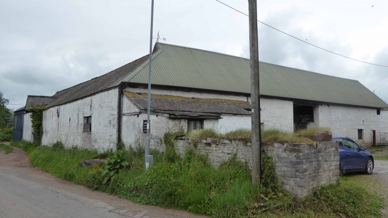
Appears on Tithe Map of 1840 in present form. Farmyard was then U shaped and opposite range side was thus apparently altered in the later C19 to provide additional access at NE. Range backing onto lane damaged by fire C20.
Large L shaped barn range consisting of a long range backing onto the lane and a return facing the farmhouse incorporating entrance to the rectangular farmyard. Of limewashed stone rubble, Welsh slate roof to long range and stone tile roof to return; inward facing pitches are corrugated. Long range comprises a barn W with two rows of ventilation slits, one blocked to roadside, high opposing double doors with gabled porch roof to lane and cart shed wing E with 2 wide bays with timber lintels and hayloft above facing farmyard. Return range has hipped roof at angle surmounted by weathervane, roughly central double doorway acting as entrance to farmyard, pitching door in gable end.
Roadside range has stone threshing floor; trusses with tie beams, some struts, 3 rows of trenched purlins, partly renwewed. Return range has pegged collar and tie trusses with 3 rows of trenched purlins, interior divided vertically and horizontally, partly used as cowshed.
Included as a large village farm barn range retaining in part a stone tiled roof in a prominent position at the entrance to Llangors village.
External links are from the relevant listing authority and, where applicable, Wikidata. Wikidata IDs may be related buildings as well as this specific building. If you want to add or update a link, you will need to do so by editing the Wikidata entry.


Other nearby listed buildings
