History in Structure

Bridge over Nant Cleisfer

A Grade II Listed Building in Llangynidr, Powys

More Photos »
Approximate Location Map
Large Map »

Coordinates

Latitude: 51.8652 / 51°51'54"N

Longitude: -3.2286 / 3°13'42"W

OS Eastings: 315499

OS Northings: 219232

OS Grid: SO154192

Mapcode National: GBR YW.SRSM

Mapcode Global: VH6CG.0C1Y

Plus Code: 9C3RVQ8C+3H

Entry Name: Bridge over Nant Cleisfer

Listing Date: 28 August 1998

Last Amended: 28 August 1998

Grade: II

Source: Cadw

Source ID: 20361

Building Class: Transport

ID on this website: 300020361

Location: Approximately 180m SSW of Llangynidr church and on a minor road between Llangynidr and B4560.

County: Powys

Community: Llangynidr

Community: Llangynidr

Built-Up Area: Llangynidr

Traditional County: Brecknockshire

Tagged with: Bridge

Find accommodation in
Llangynidr

History

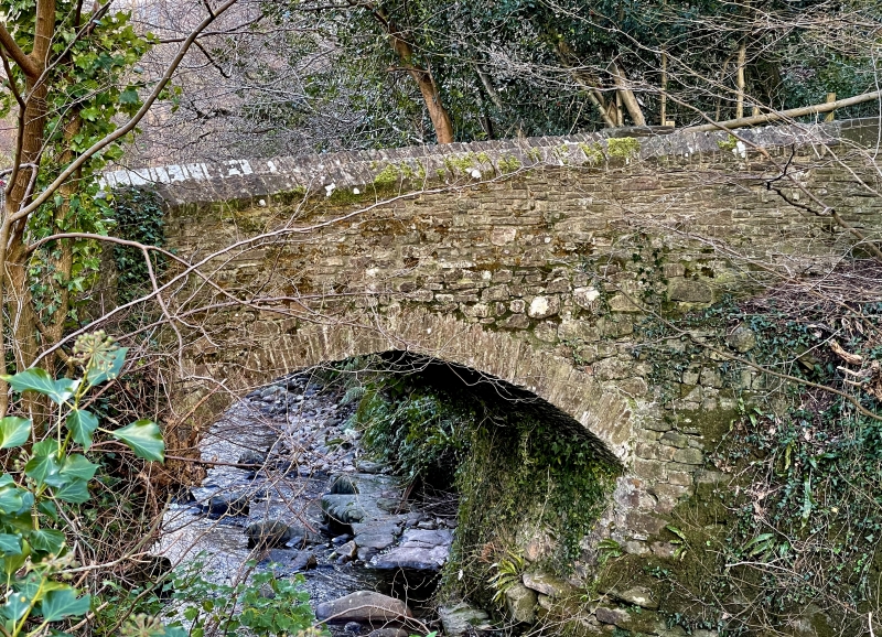
Probably early C19 bridge although probably carrying a more ancient trackway.

Exterior

Single-carriageway road bridge of rubble sandstone. A single segmental arch has thin voussoirs. The abutment curves round on E side and is continuous with garden wall of Bridge End Cottage. Low parapet curves outwards at the ends and has saddleback coping.

Reasons for Listing

A small rural road bridge retaining early character.

External Links

External links are from the relevant listing authority and, where applicable, Wikidata. Wikidata IDs may be related buildings as well as this specific building. If you want to add or update a link, you will need to do so by editing the Wikidata entry.

Recommended Books

Other nearby listed buildings

  • II Laurel Cottage
    Approximately 250m SW of Llangynidr church and on S side and set back from Mardy Lane behind forecourt walls.
  • II Danygraig
    Approximately 250m SW of Llangynidr church and on S side and set back from Mardy Lane.
  • II Bridge End Cottage
    Approximately 300m SW of Llangynidr church, on the S side of the main road through the village, E of junction with Mill Road and W of junction with Mardy Lane. Railed forecourt.
  • II War Memorial at SS Cynidr & Mary Church
    Set within the E boundary of the churchyard of the Church of St Cynidr and St Mary. Raised above the level of the road.
  • II Penyrheol (Nos 1 and 2)
    Approximately 300m SW of Llangynidr church, on W side of a minor road to Cwm Cleisfer and S side of a minor road to Dyffryn Crawnon.
  • II Saladin Cottage
    Approximately 0.4km SW of Llangynidr church, on W side of a minor road between Llangynidr village and B4560 to Beaufort.
  • II The Old Rectory
    Approximately 250m NNW of Llangynidr church and reached by private drive E of Cyffredyn Lane.
  • II Llwyncelyn
    0.8km SW of Llangynidr church and reached by private road S of B4560.

BritishListedBuildings.co.uk is an independent online resource and is not associated with any government department. All government data published here is used under licence. Please do not contact BritishListedBuildings.co.uk for any queries related to any individual listed building, planning permission related to listed buildings or the listing process itself.

British Listed Buildings is a Good Stuff website.