History in Structure

Danygraig

A Grade II Listed Building in Llangynidr, Powys

More Photos »
Approximate Location Map
Large Map »

Coordinates

Latitude: 51.8648 / 51°51'53"N

Longitude: -3.23 / 3°13'48"W

OS Eastings: 315398

OS Northings: 219188

OS Grid: SO153191

Mapcode National: GBR YW.SRFT

Mapcode Global: VH6CF.YDS8

Plus Code: 9C3RVQ79+WX

Entry Name: Danygraig

Listing Date: 28 August 1998

Last Amended: 28 August 1998

Grade: II

Source: Cadw

Source ID: 20362

Building Class: Domestic

ID on this website: 300020362

Location: Approximately 250m SW of Llangynidr church and on S side and set back from Mardy Lane.

County: Powys

Community: Llangynidr

Community: Llangynidr

Built-Up Area: Llangynidr

Traditional County: Brecknockshire

Tagged with: Cottage

Find accommodation in
Llangynidr

History

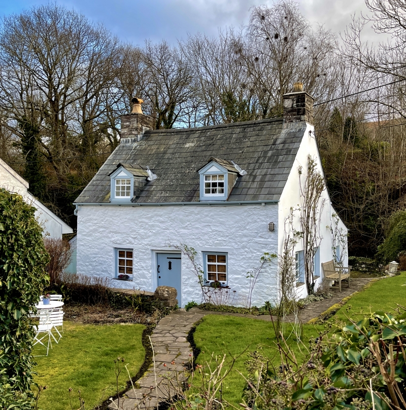
Constructed in the early C19. Wash lane to the E forming boundary with Laurel Cottage, leading to the Nant Cleisfer with masonry steps down to the river. A number of wash lanes in between the houses backing onto the Nant Cleisfer were created to provide access to water supplies for the villagers.

Exterior

Cottage of rubble sandstone painted white and slate roof with end stone stacks. One-and-a-half storeys and 2 windows. A central planked door has strap hinges and is flanked by C19 hopper windows. Similar windows to dormers, characteristic of the region. Later one-storey projection at rear.

Interior

Not inspected at time of resurvey, July 1997.

Reasons for Listing

A small early C19 cottage retaining early character and having group value with adjacent Laurel Cottage.

External Links

External links are from the relevant listing authority and, where applicable, Wikidata. Wikidata IDs may be related buildings as well as this specific building. If you want to add or update a link, you will need to do so by editing the Wikidata entry.

Recommended Books

Other nearby listed buildings

  • II Laurel Cottage
    Approximately 250m SW of Llangynidr church and on S side and set back from Mardy Lane behind forecourt walls.
  • II Bridge End Cottage
    Approximately 300m SW of Llangynidr church, on the S side of the main road through the village, E of junction with Mill Road and W of junction with Mardy Lane. Railed forecourt.
  • II Penyrheol (Nos 1 and 2)
    Approximately 300m SW of Llangynidr church, on W side of a minor road to Cwm Cleisfer and S side of a minor road to Dyffryn Crawnon.
  • II Saladin Cottage
    Approximately 0.4km SW of Llangynidr church, on W side of a minor road between Llangynidr village and B4560 to Beaufort.
  • II Bridge over Nant Cleisfer
    Approximately 180m SSW of Llangynidr church and on a minor road between Llangynidr and B4560.
  • II War Memorial at SS Cynidr & Mary Church
    Set within the E boundary of the churchyard of the Church of St Cynidr and St Mary. Raised above the level of the road.
  • II The Old Rectory
    Approximately 250m NNW of Llangynidr church and reached by private drive E of Cyffredyn Lane.
  • II Llwyncelyn
    0.8km SW of Llangynidr church and reached by private road S of B4560.

BritishListedBuildings.co.uk is an independent online resource and is not associated with any government department. All government data published here is used under licence. Please do not contact BritishListedBuildings.co.uk for any queries related to any individual listed building, planning permission related to listed buildings or the listing process itself.

British Listed Buildings is a Good Stuff website.