History in Structure

Saladin Cottage

A Grade II Listed Building in Llangynidr, Powys

More Photos »
Approximate Location Map
Large Map »

Coordinates

Latitude: 51.864 / 51°51'50"N

Longitude: -3.2306 / 3°13'50"W

OS Eastings: 315357

OS Northings: 219100

OS Grid: SO153191

Mapcode National: GBR YW.SR9Q

Mapcode Global: VH6CF.YDGW

Plus Code: 9C3RVQ79+JQ

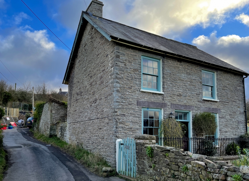
Entry Name: Saladin Cottage

Listing Date: 28 August 1998

Last Amended: 28 August 1998

Grade: II

Source: Cadw

Source ID: 20380

Building Class: Domestic

ID on this website: 300020380

Location: Approximately 0.4km SW of Llangynidr church, on W side of a minor road between Llangynidr village and B4560 to Beaufort.

County: Powys

Community: Llangynidr

Community: Llangynidr

Built-Up Area: Llangynidr

Traditional County: Brecknockshire

Tagged with: Cottage

Find accommodation in
Llangynidr

History

Mid C19 cottage.

Exterior

Two-storey cottage of rubble sandstone and slate roof with end stone stack to L. The 2-window front has openings offset to L with big stone lintels and sills, and comprises 12-pane hornless sashes and central 6-panel door with 3-pane overlight. The R gable end has a renewed sash window in the upper storey and added door and window below. The rear openings are offset to R and comprise, in the upper storey, 12-pane sashes to R and L with smaller 9-pane sash window between, while the lower storey has lately added casements and door in original openings. Added one-storey projection at L end of rear.

Interior

Not inspected at time of resurvey, July 1997.

Reasons for Listing

Good example of a mid C19 cottage in a prominent village location.

External Links

External links are from the relevant listing authority and, where applicable, Wikidata. Wikidata IDs may be related buildings as well as this specific building. If you want to add or update a link, you will need to do so by editing the Wikidata entry.

Recommended Books

Other nearby listed buildings

  • II Bridge End Cottage
    Approximately 300m SW of Llangynidr church, on the S side of the main road through the village, E of junction with Mill Road and W of junction with Mardy Lane. Railed forecourt.
  • II Danygraig
    Approximately 250m SW of Llangynidr church and on S side and set back from Mardy Lane.
  • II Penyrheol (Nos 1 and 2)
    Approximately 300m SW of Llangynidr church, on W side of a minor road to Cwm Cleisfer and S side of a minor road to Dyffryn Crawnon.
  • II Laurel Cottage
    Approximately 250m SW of Llangynidr church and on S side and set back from Mardy Lane behind forecourt walls.
  • II Bridge over Nant Cleisfer
    Approximately 180m SSW of Llangynidr church and on a minor road between Llangynidr and B4560.
  • II War Memorial at SS Cynidr & Mary Church
    Set within the E boundary of the churchyard of the Church of St Cynidr and St Mary. Raised above the level of the road.
  • II The Old Rectory
    Approximately 250m NNW of Llangynidr church and reached by private drive E of Cyffredyn Lane.
  • II Llwyncelyn
    0.8km SW of Llangynidr church and reached by private road S of B4560.

BritishListedBuildings.co.uk is an independent online resource and is not associated with any government department. All government data published here is used under licence. Please do not contact BritishListedBuildings.co.uk for any queries related to any individual listed building, planning permission related to listed buildings or the listing process itself.

British Listed Buildings is a Good Stuff website.