Latitude: 51.8649 / 51°51'53"N
Longitude: -3.2306 / 3°13'50"W
OS Eastings: 315356
OS Northings: 219194
OS Grid: SO153191
Mapcode National: GBR YW.SR8B
Mapcode Global: VH6CF.YDF7
Plus Code: 9C3RVQ79+XP
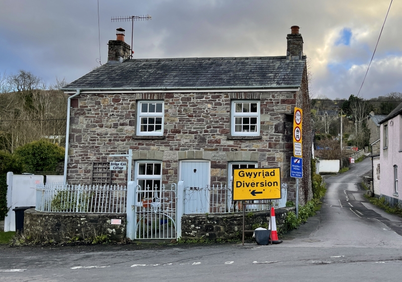
Entry Name: Bridge End Cottage
Listing Date: 28 August 1998
Last Amended: 28 August 1998
Grade: II
Source: Cadw
Source ID: 20379
Building Class: Defence
ID on this website: 300020379
Location: Approximately 300m SW of Llangynidr church, on the S side of the main road through the village, E of junction with Mill Road and W of junction with Mardy Lane. Railed forecourt.
County: Powys
Community: Llangynidr
Community: Llangynidr
Built-Up Area: Llangynidr
Traditional County: Brecknockshire
Tagged with: Cottage
Early C19 cottage shown on Llangynidr Tithe map of 1845. Said to have been the former blacksmith's cottage.
Two-storey cottage of rubble sandstone with larger quoins. The angle to R is rounded at junction with Mill Lane. Slate roof with stone stacks to R and L. The 2-window front has openings offset to R under segmental heads (large voussoirs in the lower storey and smaller in the upper storey), with 9-pane Breconshire windows and a boarded door. Good C19 spearhead railings to the front, said to have been made by the blacksmith John Owen; set on stone dwarf wall; curved to the left and with gate to the centre.
Not inspected at time of resurvey, July 1997.
Listed for its special interest as a characteristic and well-preserved early C19 village house.
External links are from the relevant listing authority and, where applicable, Wikidata. Wikidata IDs may be related buildings as well as this specific building. If you want to add or update a link, you will need to do so by editing the Wikidata entry.


Other nearby listed buildings