Approximate Location Map
Large Map »
Latitude: 51.8498 / 51°50'59"N
Longitude: -3.1505 / 3°9'1"W
OS Eastings: 320848
OS Northings: 217426
OS Grid: SO208174
Mapcode National: GBR F0.TM4R
Mapcode Global: VH6CH.BRTT
Plus Code: 9C3RRRXX+WQ
Entry Name: Pen-y-Pentre (aka The Old Factory House)
Listing Date: 21 October 1998
Last Amended: 21 October 1998
Grade: II
Source: Cadw
Source ID: 20728
Building Class: Domestic
ID on this website: 300020728
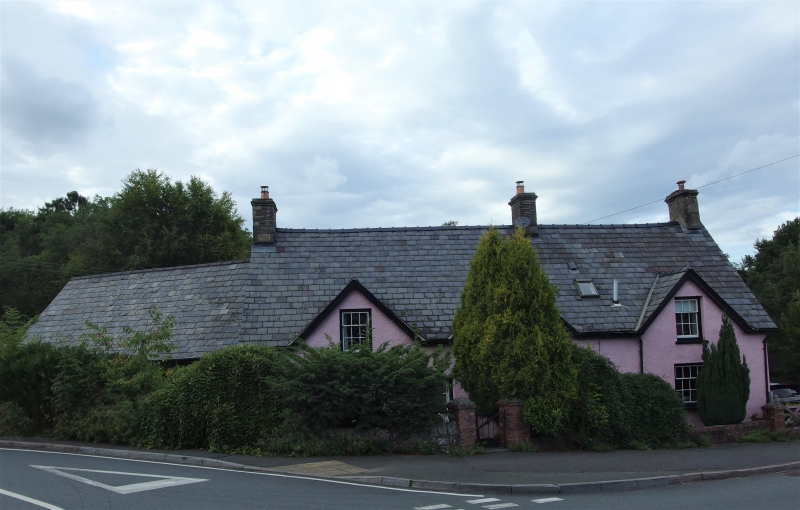
Location: Located in a prominent position in Llangattock village, at the fork of 2 roads and opposite and to the N of Bethesda Chapel. The Monmouthshire and Brecon Canal is a short distance to the SW.
County: Powys
Community: Llangattock (Llangatwg)
Community: Llangattock
Built-Up Area: Llangattock
Traditional County: Brecknockshire
Tagged with: House
House and barn said to be C17. Shown on a map of the late C18 by John Dowding. The building was used for making woollen flannel in the C19. It is recorded as being occupied by John Price, Flannel Manufacturer, in Slater’s Directory of 1850. The building is marked on the 1st edition Ordnance Survey of 1889 as ‘Woollen Factory’. The dyeing is said to have been undertaken in the former barn to the W, while the wool was stored at the E end of the house. The rear lean-to is probably late C19.
Three-window house of one and a half storeys, with adjoining barn to W, and rear lean-to. Pebble-dashed with steeply pitched slate roof (indicating C17 origins), and stone stacks to L, R and R of centre. The front has 3 wide, gabled half-dormers and 2 doors; a wood planked door to the R of centre and a C20 half-lit door to the L of centre. They are located between the 3 ground floor windows, but the arrangement is not symmetrical, the R hand window offset further to the R. The windows have flat heads and stone lintels and are 4- over 8-pane sashes to the ground floor, and 3- over 6-pane sashes to the 1st floor.
The E gable of the house has a multi-pane window off-centre. The rear of the house has a 2-casement window. There is a long added lean-to to the rear, pebble-dashed under a corrugated roof with red brick end stack. It has a C20 half-lit door in the centre flanked by 2-light casement windows, and a further similar window in the E end.
The adjoining barn is slightly lower, of limewashed rubble masonry under a slate roof. The front has double planked doors under a long timber lintel, with a further single door to the L. In the W gable end, is a small wood-framed opening in the apex, perhaps originally with timber mullions.
The interior is modernised. The house was entered through the L door. The stairs are directly ahead, with the living room to the L. On the L wall is the fireplace, and former fireplace stairs are said to curve round to its N (now covered in). There is one cross beam without chamfers in the living room, with hooks for hanging meat.
Listed as a prominently sited house of well preserved historic character with C17/ C18 origins and with particular historic interest for its later modification as a woollen factory.
External links are from the relevant listing authority and, where applicable, Wikidata. Wikidata IDs may be related buildings as well as this specific building. If you want to add or update a link, you will need to do so by editing the Wikidata entry.


Other nearby listed buildings
