Approximate Location Map
Large Map »
Latitude: 51.8927 / 51°53'33"N
Longitude: -3.2838 / 3°17'1"W
OS Eastings: 311754
OS Northings: 222351
OS Grid: SO117223
Mapcode National: GBR YT.QXTF
Mapcode Global: VH6C7.1PCF
Plus Code: 9C3RVPV8+3F
Entry Name: Former Counting House
Listing Date: 17 December 1998
Last Amended: 17 December 1998
Grade: II
Source: Cadw
Source ID: 21130
Building Class: Industrial
ID on this website: 300021130
Location: Set into the bank above the canal, one side fronting the mountain road the other the canal, on the SE edge of Talybont village.
County: Powys
Community: Talybont-on-Usk (Tal-y-bont ar Wysg)
Community: Talybont-on-Usk
Locality: Talybont on Usk
Traditional County: Brecknockshire
Tagged with: House
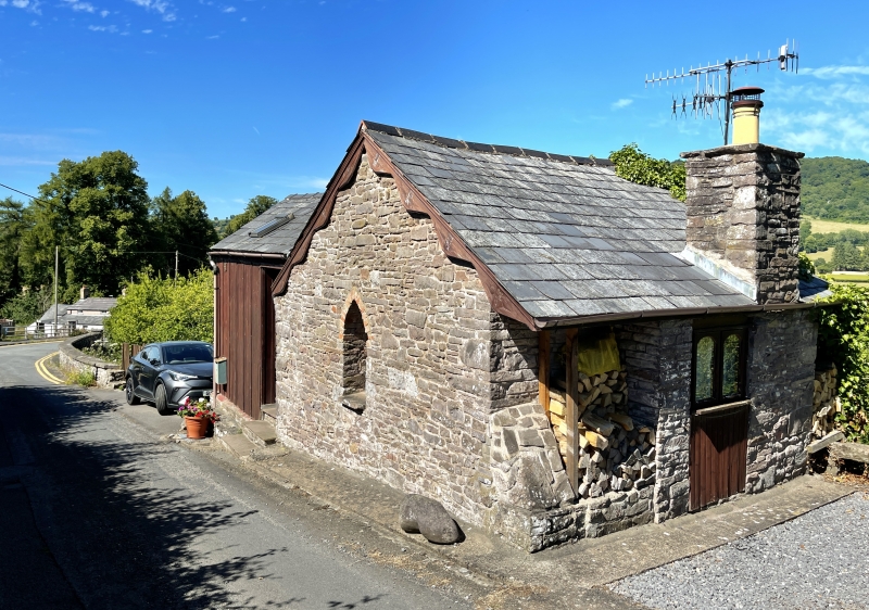
Built 1814 at the end of the Brynoer tramroad by Jonathan Dixon and owned by Snead, partner of Bromage and Snead, Brecon Bankers. The tramroad terminated here alongside canal. Lower storey fronts the Brecknock and Abergavenny canal. Refurbished and extended as a dwelling; photograph taken beforehand shows core of building much as at present.
A small building of toll-house style built into the canal bank. Of stone rubble with Welsh slate roof with decorative bargeboards, large square axial stack. Single storey single room building at roadside, 2 storeys at canal level. Pointed arched window with Gothick glazing in gable end onto road and former doorway, converted to window, with inset stone seat beside; faces up former tramroad. Timber additions to side and rear.
Converted to dwelling.
Listed for its special importance in relation to the canal and the tramroad and for special interest as part of a group of buildings associated with the canal and tramroad.
External links are from the relevant listing authority and, where applicable, Wikidata. Wikidata IDs may be related buildings as well as this specific building. If you want to add or update a link, you will need to do so by editing the Wikidata entry.


Other nearby listed buildings
