Approximate Location Map
Large Map »
Latitude: 51.5746 / 51°34'28"N
Longitude: -3.2349 / 3°14'5"W
OS Eastings: 314519
OS Northings: 186918
OS Grid: ST145869
Mapcode National: GBR HV.D503
Mapcode Global: VH6DS.WP68
Plus Code: 9C3RHQF8+V3
Entry Name: Farm Range with Bee-boles at Beddau Farmhouse
Listing Date: 18 February 1999
Last Amended: 18 February 1999
Grade: II
Source: Cadw
Source ID: 21379
Building Class: Agriculture and Subsistence
ID on this website: 300021379
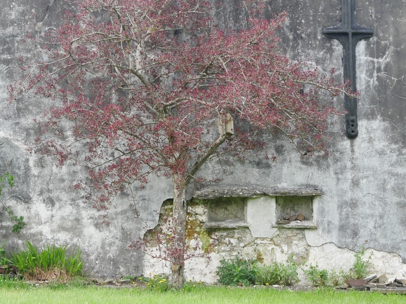
Location: Located at the junction of St Cenydd Road and Nantgarw Road. The bee-boles are in a wall overlooking the front garden of Beddau farmhouse.
County: Caerphilly
Town: Caerphilly
Community: Caerphilly (Caerffili)
Community: Caerphilly
Locality: Beddau
Built-Up Area: Caerphilly
Traditional County: Glamorgan
Tagged with: Farm
C18 - early C19. Bee-boles in long farm range, a cow-house and probable stable. The bee-boles were still in use in the 1940s.
Two adjacent bee-boles, each with projecting lintels and sills of rough monolithic stone. Located within the SE-facing wall of a long farm range. The rubble stone range is partially ruined and has lost its roof coverings. Six-bay with central masonry dividing wall and light Queen-post trusses. Planked doors face NW under segmental voussoired heads at different heights. The L half has 3 doors and the R half has 1 door. A further door under a flat head has been added to the far R. Two openings to loft. The SE wall containing the bee-boles has been rendered and whitened, and contains no other openings. One iron tie plate is fixed to the wall.
No access to interior of farm range at time of inspection (25/9/98).
Listed for the special interest of the well preserved bee-boles, a feature now becoming very rare in the area.
External links are from the relevant listing authority and, where applicable, Wikidata. Wikidata IDs may be related buildings as well as this specific building. If you want to add or update a link, you will need to do so by editing the Wikidata entry.


Other nearby listed buildings
