Approximate Location Map
Large Map »
Latitude: 53.1278 / 53°7'40"N
Longitude: -4.1509 / 4°9'3"W
OS Eastings: 256182
OS Northings: 361122
OS Grid: SH561611
Mapcode National: GBR 5P.6S67
Mapcode Global: WH54M.6NN0
Plus Code: 9C5Q4RHX+4J
Entry Name: Groeslon
Listing Date: 28 May 1999
Last Amended: 28 May 1999
Grade: II
Source: Cadw
Source ID: 21845
Building Class: Domestic
ID on this website: 300021845
Location: Located in a remote upland position directly at right-angles to Ffordd Clegir to the north-west of the former Glyn-rhonwy Slate Quarry.
County: Gwynedd
Town: Caernarfon
Community: Llanberis
Community: Llanberis
Traditional County: Caernarfonshire
Tagged with: Cottage
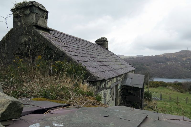
Built in the early C19, the absence of an associated cowhouse and its proximity to the nearby quarry suggest that this was primarily a quarry worker's cottage rather than part of a smallholding, its position directly by the road perhaps also indicating that it originated as an encroachment. The cottage is shown on the 1839 Tithe Map.
Single-storey cottage. Compact 2-room plan with small lean-to attached to right gable end where ground drops. Roughly coursed rubblestone blocks, some quite large; slate roof and integral end stacks with slate drips. Later C19 slate slab porch with gabled slate slab roof to centre flanked by 4-paned sashes with slate cills and lintels. 2 small windows with slate cills to back wall.
Interior not accessible at time of Survey.
Included as a well-preserved example of an early C19 quarry worker's cottage, built in the local vernacular tradition and characteristically making use of slate even for the gabled porch; the cottage forms a typical component of this upland semi-industrial landscape, with its characteristic dispersed settlement and encroachments.
External links are from the relevant listing authority and, where applicable, Wikidata. Wikidata IDs may be related buildings as well as this specific building. If you want to add or update a link, you will need to do so by editing the Wikidata entry.


Other nearby listed buildings
