Approximate Location Map
Large Map »
Latitude: 51.6021 / 51°36'7"N
Longitude: -3.0116 / 3°0'41"W
OS Eastings: 330033
OS Northings: 189731
OS Grid: ST300897
Mapcode National: GBR J5.B760
Mapcode Global: VH7B5.RZ7R
Plus Code: 9C3RJX2Q+R9
Entry Name: Gwastad Bridge over the Monmouthshire and Brecon Canal and Lock (partly in Shaftesbury Community)
Listing Date: 24 June 1999
Last Amended: 24 June 1999
Grade: II
Source: Cadw
Source ID: 21952
Building Class: Transport
Also known as: Gwastad Bridge over the Monmouthshire and Brecon Canal and Lock (partly in Bettws community)
ID on this website: 300021952
Location: Situated W of Blaen-y-pant Cresent, with open fields to the W.
County: Newport
Community: Bettws (Betws)
Community: Bettws
Locality: Blaen-y-pant Cresent
Built-Up Area: Newport
Traditional County: Monmouthshire
Tagged with: Bridge Lock Road bridge
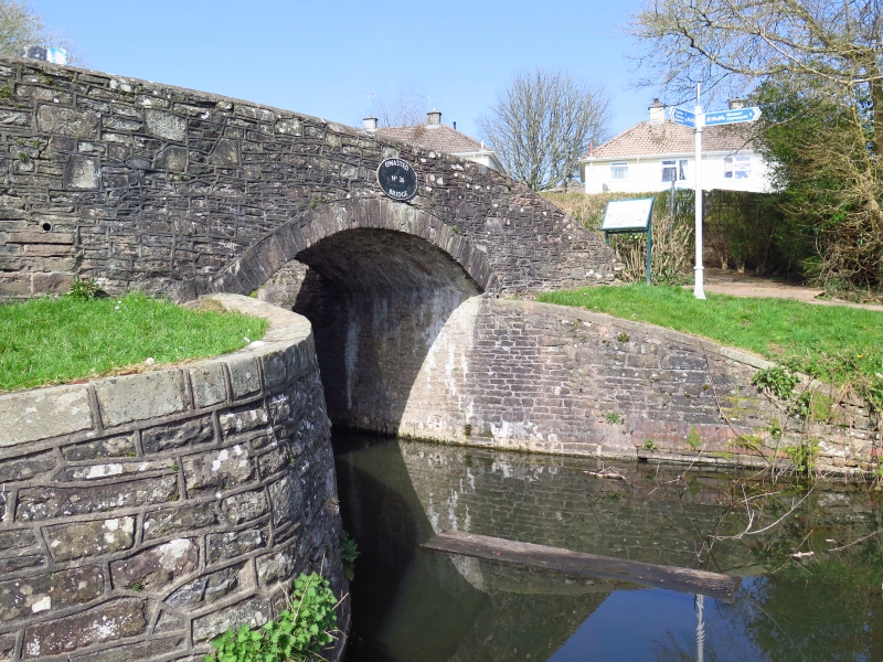
The eastern branch of the Monmouthshire and Brecon Canal was authorised by Act of Parliament in 1792, and officially opened in 1799. It ran from Newport to Pontynewynydd and was engineered by Thomas Dadford Jnr. The canal connected with several tramroadsbelonging to the same company (Monmouthshire Canal Navigation Company), carrying coal down to the wharves. The branch was 11 miles (18.6 kilometres) long, and rose 447 feet (136 metres) 42 locks. The contemporary western branch, 12 miles (20.3 kilometres) long, ran to Crumlin. In 1812, the eastern branch was connected to the Brecon and Abergavenny Canal at Pontymoile Basin, and this became the main line. In 1853-55, the Monmouthshire Railway and Canal Company built a railway down to Newport, the company amalgamating with the Great Western Railway in 1880. The canal then became increasingly disused. The Crumlin branch closed in 1949, the main line in 1962. The lock and bridge were restored in 1974 by Newport Borough Council, including the provision of new gates.
Bridge with lock chamber immediately N. Bridge carries public footpath. Single-arch bridge of rubble: segmental arch with stone voussoirs. Stone slab coping to N, cement coping to S. Stone plaque set into N parapet commemorating the 1974 restoration. Splayed revetments to S side. N parapet walls continue as retaining wall for lock-platform. Iron plaque to S face of bridge: 'Gwastad No. 26 Bridge'. The lock chamber is of rubble, with sandstone copings. Lock gates of 1974. Overflow culvert to E; towpath runs along W side.
Listed as a significant element of the engineering works associated with the Monmouthshire and Brecon Canal; well-restored in 1974.
External links are from the relevant listing authority and, where applicable, Wikidata. Wikidata IDs may be related buildings as well as this specific building. If you want to add or update a link, you will need to do so by editing the Wikidata entry.


Other nearby listed buildings
