History in Structure

Pistyll Limeworks chimney

A Grade II Listed Building in Llandybie, Carmarthenshire

More Photos »
Approximate Location Map
Large Map »

Coordinates

Latitude: 51.8324 / 51°49'56"N

Longitude: -4.0001 / 4°0'0"W

OS Eastings: 262279

OS Northings: 216761

OS Grid: SN622167

Mapcode National: GBR DW.VLG2

Mapcode Global: VH4J9.M65L

Plus Code: 9C3QRXJX+XX

Entry Name: Pistyll Limeworks chimney

Listing Date: 27 August 1999

Last Amended: 27 August 1999

Grade: II

Source: Cadw

Source ID: 22229

Building Class: Industrial

ID on this website: 300022229

Location: To the west side of Pistyll Limeworks

County: Carmarthenshire

Town: Ammanford

Community: Llandybie (Llandybïe)

Community: Llandybie

Locality: Pistyll

Traditional County: Carmarthenshire

Tagged with: Lime kiln

Find accommodation in
Derwydd

History

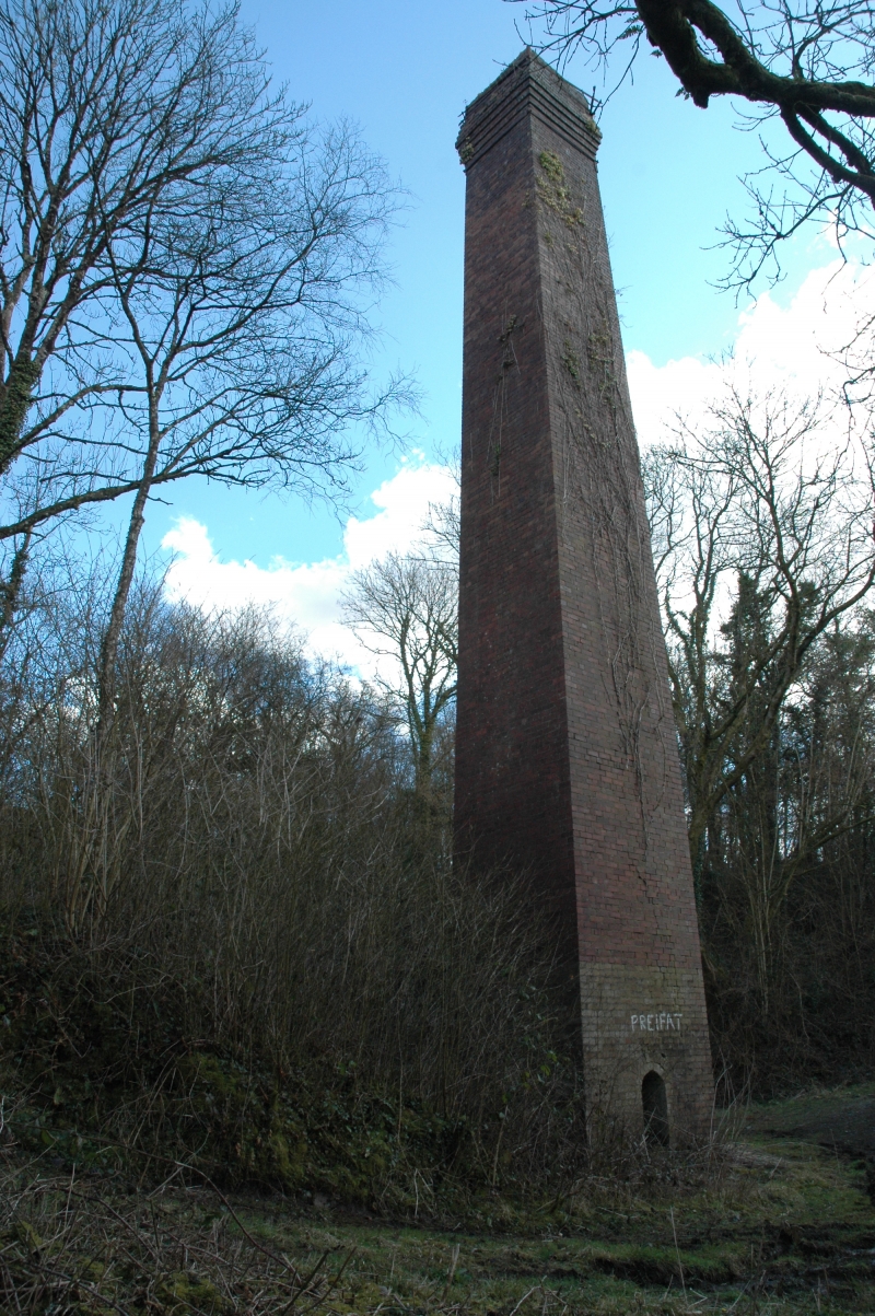
Late C19 or early C20 chimney probably intended for a works boilerhouse, as part of the Pistyll Limeworks. (Not marked on the 1876 Ordnance Survey map.)

Exterior

A square brickwork chimney about 20m in height, tapering from about 2m at base to about 1½m at top. Cornice of about 4 corbelled courses near the top, with reducing courses above. Small arched apertures at base at east and west sides.

Reasons for Listing

Listed for group value with Pistyll Limekilns.

External Links

External links are from the relevant listing authority and, where applicable, Wikidata. Wikidata IDs may be related buildings as well as this specific building. If you want to add or update a link, you will need to do so by editing the Wikidata entry.

Recommended Books

Other nearby listed buildings

  • II Pistyll Limekilns
    1 km north of Llandybie village by the A483, reached by a farm track 200m south from the Afon Marlais bridge. Large quarry to east side. Extensive traces of industrial buildings to the immediate west,
  • II* Cil-yr-ychen Lime Kilns
    Prominently sited 200m to the west of Llandeilo Road, about 1½ km north of Llandybie village.
  • II Felin Wen, Llandybie
    About 1km north of Llandybie village, reached by a lane west of Llandeilo Road. North side of the Marlais stream.
  • II Cil-yr-ychen Farmhouse
    To the north side of a lane between Derwydd Mansion and Cilyrychen Industrial Estate.
  • II Cil-yr-ychen Barn Range
    At west side of Cil-yr-ychen farmyard.
  • II Agricultural Range Opposite Red Lion Inn
    Detached immediately opposite the Red Lion Hotel, on the northern edge of Llandybie; farmyard to rear and to left.
  • II The Mill House, Llandybie
    To the east of Llandybie mill. Stone rubble enclosing wall (modern concrete blockwork to street side) with steps down to the mill yard.
  • II* Church of St. Tybie
    At the centre of Llandybie village. Large stone-walled graveyard to north side (recent parts walled in concrete blocks). High wall with steps and iron gates from the street at west and south; stile be

BritishListedBuildings.co.uk is an independent online resource and is not associated with any government department. All government data published here is used under licence. Please do not contact BritishListedBuildings.co.uk for any queries related to any individual listed building, planning permission related to listed buildings or the listing process itself.

British Listed Buildings is a Good Stuff website.