Approximate Location Map
Large Map »
Latitude: 53.021 / 53°1'15"N
Longitude: -4.3646 / 4°21'52"W
OS Eastings: 241490
OS Northings: 349695
OS Grid: SH414496
Mapcode National: GBR 5D.FN79
Mapcode Global: WH43Y.XBSC
Plus Code: 9C5Q2JCP+C4
Entry Name: Lychgate to the churchyard of the Church of St Beuno
Listing Date: 29 May 1968
Last Amended: 15 September 1999
Grade: II
Source: Cadw
Source ID: 22351
Building Class: Religious, Ritual and Funerary
ID on this website: 300022351
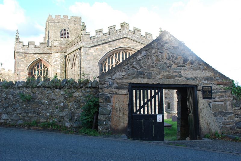
Location: The lychgate opens directly off the main road at the centre of the village, and leads into the W corner of the churchyard opposite the E end of the chancel.
County: Gwynedd
Town: Caernarfon
Community: Clynnog
Community: Clynnog
Locality: Clynnog-fawr
Traditional County: Caernarfonshire
Tagged with: Lychgate
Built in the late medieval period as the main entrance to the churchyard.
Built of granite with a pitched slate roof. Double gate entry from the road to a wide interior paved with pebbles, and slate and slopes down to the wide opening to the churchyard. Both openings are covered by a large single slab of stone of irregular shape, on further corbel slabs, the inner opening having a square opening to admit more light set asymmetrically above the lintel. The entry against the road appears to have been originally arched.
The roof is carried on re-used oak purlins and a ridge and has open rafters with plaster between each. The passage has one shallow recessed seat each side immediately behind the outer gates, perhaps for mendicant pilgrims.
Included as a good example of a late medieval lychgate to a churchyard, and of group value with the Grade I Church of St Beuno and other structures at the centre of Clynnog-fawr.
External links are from the relevant listing authority and, where applicable, Wikidata. Wikidata IDs may be related buildings as well as this specific building. If you want to add or update a link, you will need to do so by editing the Wikidata entry.


Other nearby listed buildings
