History in Structure

Milestone

A Grade II Listed Building in Llanddeiniolen, Gwynedd

More Photos »
Approximate Location Map
Large Map »

Coordinates

Latitude: 53.1617 / 53°9'42"N

Longitude: -4.216 / 4°12'57"W

OS Eastings: 251941

OS Northings: 365025

OS Grid: SH519650

Mapcode National: GBR 5L.4VQ6

Mapcode Global: WH54D.6SMJ

Plus Code: 9C5Q5Q6M+MH

Entry Name: Milestone

Listing Date: 4 November 1999

Last Amended: 4 November 1999

Grade: II

Source: Cadw

Source ID: 22632

Building Class: Transport

ID on this website: 300022632

Location: Situated on south side of the B 4366 approximately 0.5 km south-west of Bethel.

County: Gwynedd

Community: Llanddeiniolen

Community: Llanddeiniolen

Locality: Bethel

Traditional County: Caernarfonshire

Tagged with: Milestone

Find accommodation in
Port Dinorwic

History

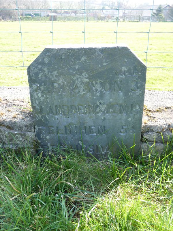
Early to mid-C19 milestone relating to the turnpike road first established in the 1820s.

Exterior

Slate-stone with simple chamfered top edge set in field boundary. Inscribed "MILES" to top right corner with below "CARNARVON 3/ LLANDEINIOLEN 1 3/4/ FELINHEN 5 1/4/ BETHESDA 8".

Reasons for Listing

Included for its special historic interest as a turnpike road milestone, a well-preserved example of a characteristic local type.

External Links

External links are from the relevant listing authority and, where applicable, Wikidata. Wikidata IDs may be related buildings as well as this specific building. If you want to add or update a link, you will need to do so by editing the Wikidata entry.

Recommended Books

Other nearby listed buildings

  • II Ddol
    Situated in a large yard area with a modern bungalow to the north at the end of a short track running off the south-east side of the B4366, approximately 0.5km south-west of Bethel.
  • II Sunday School/Vestry at Capel Bethel including railings to forecourt
    Situated in forecourt immediately to south-west of Capel Bethel behind continuation of wall and railings to chapel; set of gates in line with entrance to building.
  • II Obelisk Memorial to Robert Griffith
    Set in forecourt to Sunday School/Vestry at Capel Bethel.
  • II Capel Bethel including railings to forecourt
    Situated towards south-western end of main village street near the point where it joins the B 4366; small forecourt in front has low rubblestone wall with slate coping, fleur-de-lys pointed iron raili
  • II Griffith Family Monument
    Situated in the graveyard immediately to the rear of Capel Bethel near the chapel's north-western corner.
  • II Erw-pwll-y-glo
    On narrow lane north-west of the Afon Seiont about 0.8km north of Pont-rug with rubblestone wall to lane, continuing along track towards farmbuildings on south; railings to south of house on low curvi
  • II Glan Seiont
    Located on the edge of pasture fields at the end of a track off the A 4086 approximately 1.2 km north-west of Llanrug; the building is situated about 300m south-west of the point where the former Caer
  • II Tyddyn-y-berth
    Situated at end of farm track amongst fields on east side of minor road between Llanrug and Bethel; its farmbuildings (not included on this list) lie immediately to the south.

BritishListedBuildings.co.uk is an independent online resource and is not associated with any government department. All government data published here is used under licence. Please do not contact BritishListedBuildings.co.uk for any queries related to any individual listed building, planning permission related to listed buildings or the listing process itself.

British Listed Buildings is a Good Stuff website.