Approximate Location Map
Large Map »
Latitude: 51.5885 / 51°35'18"N
Longitude: -4.1947 / 4°11'41"W
OS Eastings: 248052
OS Northings: 190026
OS Grid: SS480900
Mapcode National: GBR GS.1ZHN
Mapcode Global: VH3MX.7BRK
Plus Code: 9C3QHRQ4+C4
Entry Name: Well in Robin's Lane
Listing Date: 10 February 2000
Last Amended: 10 February 2000
Grade: II
Source: Cadw
Source ID: 22851
Building Class: Water Supply and Drainage
ID on this website: 300022851
Location: At east side of lane, about 100 m south of the Post Office.
County: Swansea
Town: Swansea
Community: Reynoldston
Community: Reynoldston
Locality: Reynoldston Village
Built-Up Area: Reynoldston
Traditional County: Glamorgan
Tagged with: Well
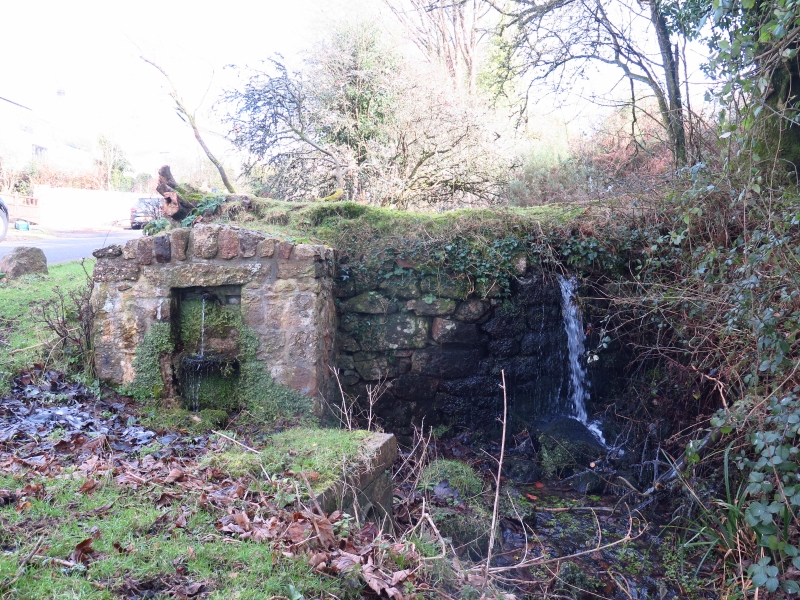
A C19 well head structure formed at an ancient village well site; known, in conformity with the dedication of the church, as St. George's well. It was referred to in 1811. This was one of two wells anciently providing water to the villagers of Reynoldston. The covering of the supply of water was probably formed for reasons of hygiene, as in the case of a similar ancient well in the centre of the adjacent parish of Llangennith. The well was a major water supply to the village. The water is said to be very pure, and was recently (1998) said still to be used occasionally by local people.
The water now issues from a pipe protected by two piers of local sandstone masonry with a lintel and a rough coping of upright stones. The whole wellhead structure is about 1.5 metres wide and tall. The adjacent pond does not feed this well.
Included for historic interest as an ancient village water supply point, the well head an example of C19 measures to protect public health.
External links are from the relevant listing authority and, where applicable, Wikidata. Wikidata IDs may be related buildings as well as this specific building. If you want to add or update a link, you will need to do so by editing the Wikidata entry.


Other nearby listed buildings
