Approximate Location Map
Large Map »
Latitude: 53.1246 / 53°7'28"N
Longitude: -4.0204 / 4°1'13"W
OS Eastings: 264904
OS Northings: 360515
OS Grid: SH649605
Mapcode National: GBR 5V.71W7
Mapcode Global: WH54P.6QSF
Plus Code: 9C5Q4XFH+VV
Entry Name: Pont Pen-y-benglog
Listing Date: 9 March 2000
Last Amended: 9 March 2000
Grade: II
Source: Cadw
Source ID: 22944
Building Class: Transport
ID on this website: 300022944
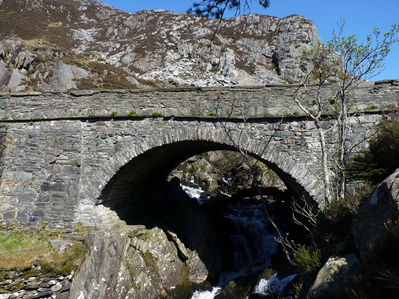
Location: Situated on the A 5 above the spectacular Pen-y-benglog falls at the narrow west end of Llyn Ogwen.
County: Gwynedd
Community: Llanllechid
Community: Llanllechid
Locality: Pen-y-benglog
Traditional County: Caernarfonshire
Tagged with: Road bridge
The small late C18 bridge can be seen underneath the main bridge on its widened eastern side. This widening and rebuilding took place in 1928, before which the original bridge stood alongside the larger and taller bridge built by Thomas Telford in the 1820s as part of the turnpiking of the London to Holyhead road between 1815 and 1830. The original width of Telford's bridge can clearly be seen in the soffit of the present structure.
The original bridge is the small single-span segmental-arched rubblestone structure on the eastern side, now denuded of its road surface. This was superseded by the larger and higher structure following the curve of the road immediately to its west (see History), built of irregularly coursed rubblestone with slate string course and slate coping to parapet; wide single-span segmental arch with voussoirs and very simple tapering pilaster buttresses to each side. The eastern side of this bridge is completely hidden by the mid-C20 widening on the eastern side directly above the small C18 bridge; the C20 work is of roughly coursed rubblestone, the arch following the shape of Telford's bridge to the west; string course and regular pilaster buttresses to straight parapet on this side.
Included, notwithstanding the rebuilding on the eastern side, as a good example of a bridge on Thomas Telford's nationally important London to Holyhead road incorporating the remains of an earlier bridge below; provides a graphic illustration of the history and development of road building in this area.
External links are from the relevant listing authority and, where applicable, Wikidata. Wikidata IDs may be related buildings as well as this specific building. If you want to add or update a link, you will need to do so by editing the Wikidata entry.


Other nearby listed buildings
