History in Structure

Horse Drinking Trough and Fountain

A Grade II Listed Building in Llandygai, Gwynedd

More Photos »
Approximate Location Map
Large Map »

Coordinates

Latitude: 53.2166 / 53°12'59"N

Longitude: -4.0957 / 4°5'44"W

OS Eastings: 260161

OS Northings: 370888

OS Grid: SH601708

Mapcode National: GBR 5R.17KC

Mapcode Global: WH548.1DXY

Plus Code: 9C5Q6W83+JP

Entry Name: Horse Drinking Trough and Fountain

Listing Date: 24 May 2000

Last Amended: 24 May 2000

Grade: II

Source: Cadw

Source ID: 23393

Building Class: Water Supply and Drainage

ID on this website: 300023393

Location: Built into the park wall to Penrhyn Castle on the north side of the road between Llandygai and Tal-y-bont approximately 40m west of the bridge over the Afon Ogwen.

County: Gwynedd

Community: Llandygai (Llandygái)

Community: Llandygai

Traditional County: Caernarfonshire

Tagged with: Architectural structure

Find accommodation in
Llanllechid

History

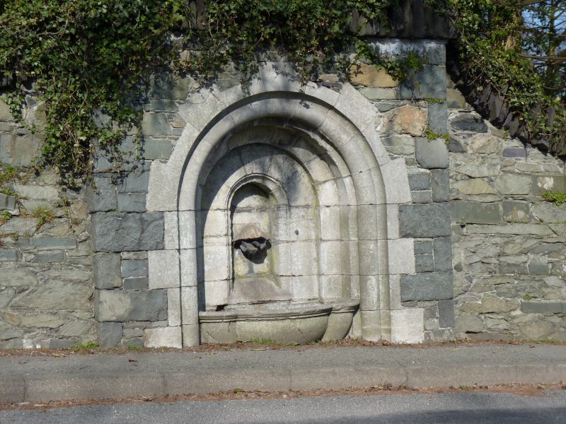
Built into the park wall of Penrhyn Castle at the instigation of George Hay Dawkins-Pennant in 1834.

Exterior

Horse drinking trough and fountain, built into the park wall of Penrhyn Castle. Round-arched recess in 3 orders constructed of Anglesey limestone set into slight projection from park wall, inner arch framing niche with copper pipe discharging through carved shell into lobed trough below with moulded rim; inscription around inner arch records that the structure was erected by George Hay Dawkins Pennant on 17 February 1834.

Reasons for Listing

Included as a well-preserved and distinctive feature of the early to mid-C19 planned estate village of Llandygai.

External Links

External links are from the relevant listing authority and, where applicable, Wikidata. Wikidata IDs may be related buildings as well as this specific building. If you want to add or update a link, you will need to do so by editing the Wikidata entry.

Recommended Books

Other nearby listed buildings

  • II Pont Tal-y-bont (partly in Llanllechid community)
    Spans the Afon Ogwen on the road between Llanygai and Tal-y-bont; park land of Penrhyn Park to north.
  • II Pont Tal-y-bont (partly in Llandygai community)
    Spans the Afon Ogwen on the road between Llanygai and Tal-y-bont; park land of Penrhyn Park to north.
  • II* Wyatt Memorial at the Church of St Tegai
    Located directly to the south of the chancel of the Church of St Tegai.
  • II* Church of St Tegai
    Located at north-eastern end of village.
  • II Former Sawmill Manager's House
    Situated directly to the east of Tre-felin Cottages at the entrance to the former Tre-felin Saw Mill in the shadow of the viaduct of the Chester to Holyhead railway; curved rubblestone wall with slate
  • II Ysgol Llandygai & School House
    Situated in centre of village to south-west of church; school has playground to front and front garden of School House is boarded by substantial rubblestone block wall with regularly spaced buttresses
  • II Neuadd Talgai
    Situated directly to the north of the Church of St Tegai with the wall to Penrhyn Park to the north; separated from the churchyard by the railings running along the northern side of its yew-lined aven
  • II Tre-felin Cottages
    One of a series of 4 paired cottages following curve of road and thus forming a crescent to west of the former Tre-felin Sawmill; low rubblestone wall to roadside, while to south are long gardens terr

BritishListedBuildings.co.uk is an independent online resource and is not associated with any government department. All government data published here is used under licence. Please do not contact BritishListedBuildings.co.uk for any queries related to any individual listed building, planning permission related to listed buildings or the listing process itself.

British Listed Buildings is a Good Stuff website.