History in Structure

Granary at Lower Tresenny

A Grade II Listed Building in Grosmont, Monmouthshire

More Photos »
Approximate Location Map
Large Map »

Coordinates

Latitude: 51.912 / 51°54'43"N

Longitude: -2.8609 / 2°51'39"W

OS Eastings: 340880

OS Northings: 224072

OS Grid: SO408240

Mapcode National: GBR FD.PLZD

Mapcode Global: VH78X.C6FK

Plus Code: 9C3VW46Q+RM

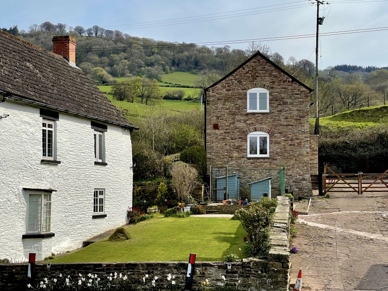
Entry Name: Granary at Lower Tresenny

Listing Date: 19 October 2000

Last Amended: 19 October 2000

Grade: II

Source: Cadw

Source ID: 24148

Building Class: Agriculture and Subsistence

ID on this website: 300024148

Location: Some 400m SE of Grosmont village, S of the road junction to Middle Tresenny.

County: Monmouthshire

Town: Abergavenny

Community: Grosmont (Y Grysmwnt)

Community: Grosmont

Locality: Tresenny

Traditional County: Monmouthshire

Tagged with: Granary

Find accommodation in
Grosmont

History

A probably early C19 granary. The ground-floor cowhouse may formerly have been a cider house.

Exterior

W elevation, first floor has centre boarded doorway to granary, and below partly collapsed stone stair. Ground floor, to left of stair has doorway with segmental voussoired arch and boarded half door. N gable has been rebuilt in late C20, and has similar segmental arch openings with boarded shutters to ground and loft floors. Opposing S gable, first floor has similar voussoired opening and ground floor doorway with timber lintel to cowhouse.

Reasons for Listing

Included for group value with the farmhouse and listed farm buildings at Lower Tresenny.

External Links

External links are from the relevant listing authority and, where applicable, Wikidata. Wikidata IDs may be related buildings as well as this specific building. If you want to add or update a link, you will need to do so by editing the Wikidata entry.

Recommended Books

Other nearby listed buildings

  • II Lower Tresenny Farmhouse
    Some 400m SE of Grosmont village, S of the road junction to Middle Tresenny.
  • II* Barn at Lower Tresenny
    400m SE of Grosmont village, immediately S of the road junction to Middle Tresenny, and some 30m SW of Lower Tresenny farmhouse.
  • II Old Tan House
    Prominently sited on the SE approach to Grosmont village, approximately 100m E of St Nicholas's Church.
  • II Athelstan
    70m NE of the Church of St Nicholas, Grosmont. The front is bounded by a narrow forecourt enclosed by decorative iron railings.
  • II Alma House including Railed Forecourt
    In Grosmont village about 50m E of the Church of St Nicholas.
  • I Church of St Nicholas
    In the centre of Grosmont in a large, gently sloping churchyard which contains a range of well-preserved memorials and chest tombs.
  • II Woodview
    At the roadside, approximately 50m N of St Nicholas's Church, next the lane leading to Grosmont Castle.
  • II Coach House at The Post Office
    Some 40m N of the Church of St Nicholas, to E of the entrance gates to churchyard.

BritishListedBuildings.co.uk is an independent online resource and is not associated with any government department. All government data published here is used under licence. Please do not contact BritishListedBuildings.co.uk for any queries related to any individual listed building, planning permission related to listed buildings or the listing process itself.

British Listed Buildings is a Good Stuff website.