History in Structure

Pant-y-cryntach

A Grade II Listed Building in Mechell, Isle of Anglesey

More Photos »
Approximate Location Map
Large Map »

Coordinates

Latitude: 53.3794 / 53°22'45"N

Longitude: -4.4261 / 4°25'33"W

OS Eastings: 238721

OS Northings: 389693

OS Grid: SH387896

Mapcode National: GBR HMFR.Z79

Mapcode Global: WH425.ZBH3

Plus Code: 9C5Q9HHF+QH

Entry Name: Pant-y-cryntach

Listing Date: 2 May 2001

Last Amended: 2 May 2001

Grade: II

Source: Cadw

Source ID: 25166

Building Class: Domestic

ID on this website: 300025166

Location: Set back from the S side of a country road c600m NE of the village of Carreglefn.

County: Isle of Anglesey

Town: Amlwch

Community: Mechell

Community: Mechell

Locality: Carreglefn

Traditional County: Anglesey

Tagged with: Cottage

Find accommodation in
Llanfechell

History

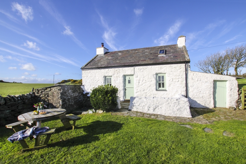
Late C18 or early C19 cottage. There are no cottages marked on the Tithe Map of the parish of Llanbadrig, 1844; the land on which it stands part of the farmstead of Clegyrog Ganol, owned by Owen Thomas Bulkeley Esq.

Exterior

Single storey vernacular cottage with lean-to abutting the NE corner. Built of local stone, limewashed; modern slate roof with stone coping and rectangular gable stacks with capping. The entrance elevation faces SE, central doorway with flanking windows with slate sills; the door is a modern boarded door and the windows 4-pane replacement casements. The lean-to has a profiled roof of modern material and a single doorway to front (SE).

Interior

Interior not inspected at the time of the survey.

Reasons for Listing

Listed as a late C18 or early C19 cottage which, notwithstanding modernisation, retains its vernacular character.

External Links

External links are from the relevant listing authority and, where applicable, Wikidata. Wikidata IDs may be related buildings as well as this specific building. If you want to add or update a link, you will need to do so by editing the Wikidata entry.

Recommended Books

Other nearby listed buildings

  • II Cottage at Pant-y-Gist
    In an isolated rural location, set well back from the NE side of a country road and set above the Afon Wygyr; c1km NE of the village of Carreglefn.
  • II Ty Newydd
    Set at right angles to the W side of the country road leading through the centre of the village of Carreglefn; abutted by the northernmost Hen Bont Cottage.
  • II Hen Bont
    Set along the W side of the country road leading through the centre of the village of Carreglefn; the S cottage is at the L (S) end of the row of two.
  • II Y Stryd
    Set along the W side of the country road leading through the centre of the village of Carreglefn; the S cottage is at the L (S) end of the row of two.
  • II Church of St Mary
    Set back, within a rectangular churchyard, from the SW side of the country road in the rural hamlet of Bodewryd; c3km ESE of Llanfechell.
  • II Dovecote at Plas Bodewryd
    In an isolated rural location, set back from the NE side of the country road in the hamlet of Bodewryd; c100m WSW of Plas Bodewryd and c250m NW of the Church of St Mary.
  • II Lychgate at Church of St Mary
    Located at the entrance of the churchyard to the Church of St Mary at Bodewryd; c3km ESE of Llanfechell.
  • II* Plas Bodewryd
    Set back from the NE side of the country road in the rural hamlet of Bodewryd, c3km ESE of Llanfechell. Plas Bodewryd lies c200m due N of the Church of St Mary.

BritishListedBuildings.co.uk is an independent online resource and is not associated with any government department. All government data published here is used under licence. Please do not contact BritishListedBuildings.co.uk for any queries related to any individual listed building, planning permission related to listed buildings or the listing process itself.

British Listed Buildings is a Good Stuff website.