History in Structure

Barn and stable range at Llanbradach Fawr

A Grade II Listed Building in Ystrad Mynach, Caerphilly

More Photos »
Approximate Location Map
Large Map »

Coordinates

Latitude: 51.6244 / 51°37'27"N

Longitude: -3.2484 / 3°14'54"W

OS Eastings: 313673

OS Northings: 192466

OS Grid: ST136924

Mapcode National: GBR HV.8TWP

Mapcode Global: VH6DL.NF1L

Plus Code: 9C3RJQF2+PJ

Entry Name: Barn and stable range at Llanbradach Fawr

Listing Date: 18 July 2001

Last Amended: 18 July 2001

Grade: II

Source: Cadw

Source ID: 25539

Building Class: Agriculture and Subsistence

ID on this website: 300025539

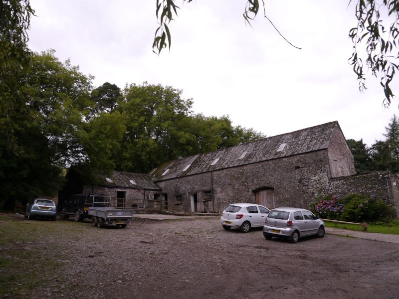
Location: Farmyard is on uphill side of the house and this barn is roughly parallel with the house.

County: Caerphilly

Community: Gelligaer

Community: Gelligaer

Locality: Llanbradach

Built-Up Area: Ystrad Mynach

Traditional County: Glamorgan

Tagged with: Barn

Find accommodation in
Caerphilly

History

Probably early C19. Shown on Tithe Map of 1842 as a long range with separate building at a right angle to left. On OS map of 1877 the range is L-shaped as now, incorporating or replacing the former separate building.

Exterior

Long barn and stable range. Unit to right has cambered arched doorway with double doors and blocked loft opening, another in gable end where reduced range with window and end door adjoins; blocked small opening with hood low to right of doorway. Unit to left has door flanked by 2 windows and further opening end left where cross range adjoins.

Interior

Downhill end is now open to roof with light-weight pegged trusses.

Reasons for Listing

Included as a substantial barn range for group value with Llanbradach Fawr.

External Links

External links are from the relevant listing authority and, where applicable, Wikidata. Wikidata IDs may be related buildings as well as this specific building. If you want to add or update a link, you will need to do so by editing the Wikidata entry.

Recommended Books

Other nearby listed buildings

  • II Llanbradach Fawr
    Situated on the mountainside on the W slope of the Rhymney Valley, SW of Ystrad Mynach, and reached by a long lane from Llanbradach to S.
  • II The Old Mill
    Set slightly back from the main thoroughfare and on the opposite side of Nant Llanbradach from the Forge.
  • II Mill Forge
    On the southern border of Ystrad Mynach, on the W bank of Rhymney River, fronting the thoroughfare.
  • II Ystrad Mynach South Signal Box
    To the south of Ystrad Mynach station on the west side of the tracks off a rough lane from Twyn Road. Private property.
  • II Old Fire Station
    Originally situated off Park Road but now resited in grounds of Caerphilly County Borough Council offices at Ystrad Fawr, to W of main house.
  • II War Memorial
    Just off Caerphilly Road in a square to the north of Ysbyty Ystrad Fawr, approx. 50m W of the Old Fire Station (rec no 13569).
  • II Taranymwrthwl Farm
    At the N end of the village and set back from the W side of the main road through Llanbradach.
  • II Former Llanbradach Colliery engine hall
    Llanbradach Colliery is on the steep hillside to the W of the village. The engine hall is on the uppermost level at the NW end of the colliery.

BritishListedBuildings.co.uk is an independent online resource and is not associated with any government department. All government data published here is used under licence. Please do not contact BritishListedBuildings.co.uk for any queries related to any individual listed building, planning permission related to listed buildings or the listing process itself.

British Listed Buildings is a Good Stuff website.