Approximate Location Map
Large Map »
Latitude: 53.2072 / 53°12'25"N
Longitude: -3.1327 / 3°7'57"W
OS Eastings: 324447
OS Northings: 368392
OS Grid: SJ244683
Mapcode National: GBR 70.1TTJ
Mapcode Global: WH76Z.VNF4
Plus Code: 9C5R6V48+VW
Entry Name: Glyndwr House
Listing Date: 15 August 2001
Last Amended: 15 August 2001
Grade: II
Source: Cadw
Source ID: 25688
Building Class: Domestic
ID on this website: 300025688
Location: The house fronts the High Street.
County: Flintshire
Town: Mold
Community: Northop (Llaneurgain)
Community: Northop
Built-Up Area: Northop
Traditional County: Flintshire
Tagged with: House
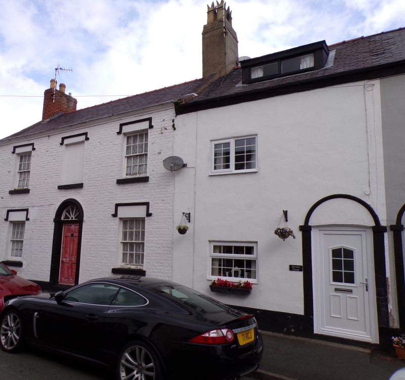
Late Georgian town house. An enlarged window to the L and adjacent door to gable end suggest that a shop was located here, probably in the late C19.
Two-storey 3-window house constructed of whitened brickwork under a slate roof with brick end stacks, rendered to R. Stone quoins and moulded eaves. The W gable end is pebble-dashed; another building adjoins to the E. Central round-arched doorcase containing a recessed panelled door with fanlight. To the R is an 8-over-8-pane hornless sash window with high square hoodmould and stone sill. To the L is a large late C19 4-pane window with moulded reveals (including quatrefoil bosses to tops) and a square lintel. The windows to the upper storey are as lower R; 8-over-8-pane sashes with high square hoodmoulds, but the central window is blind. To the S gable end are double panelled doors under a high hoodmould, offset to the R. 2 cat-slide extensions to rear also of whitened brickwork: western elevation has 16-pane sash to ground floor and casement with hoodmould above. 4-pane horizontal sliding sashes to rear.
No access to interior at time of inspection.
Listed as a good, little altered, late Georgian town house.
External links are from the relevant listing authority and, where applicable, Wikidata. Wikidata IDs may be related buildings as well as this specific building. If you want to add or update a link, you will need to do so by editing the Wikidata entry.


Other nearby listed buildings
