History in Structure

Cross in churchyard of the church of St Catwg

A Grade II Listed Building in Mitchel Troy, Monmouthshire

More Photos »
Approximate Location Map
Large Map »

Coordinates

Latitude: 51.7637 / 51°45'49"N

Longitude: -2.7587 / 2°45'31"W

OS Eastings: 347735

OS Northings: 207492

OS Grid: SO477074

Mapcode National: GBR JH.04SL

Mapcode Global: VH870.4XFV

Plus Code: 9C3VQ67R+FG

Entry Name: Cross in churchyard of the church of St Catwg

Listing Date: 27 September 2001

Last Amended: 27 September 2001

Grade: II

Source: Cadw

Source ID: 25772

Building Class: Religious, Ritual and Funerary

Also known as: St. Catwg's Churchyard Cross, Cwmcarfan

ID on this website: 300025772

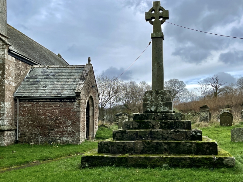
Location: About 20m S of the W end of the church.

County: Monmouthshire

Town: Monmouth

Community: Mitchel Troy (Llanfihangel Troddi)

Community: Mitchel Troy

Locality: Cwmcarvan

Traditional County: Monmouthshire

Tagged with: Christian cross Cross base

Find accommodation in
Llanishen

History

The base is probably later medieval; the cross modern.

Exterior

An unusually large and strongly-built base of a churchyard cross, with a modern replacement cross. Built of large roughly-dressed rectangular blocks of stone. Almost 4m square, with 5 steps up to a square 2-stage pedestal, the upper stage octagonal with bulbous stops.

Reasons for Listing

Included for group value with the church.

External Links

External links are from the relevant listing authority and, where applicable, Wikidata. Wikidata IDs may be related buildings as well as this specific building. If you want to add or update a link, you will need to do so by editing the Wikidata entry.

Recommended Books

Other nearby listed buildings

  • II* Church of St Catwg
    In a relatively isolated position about 2.4km SSW of Monmouth, in the fork of two lanes which run S up towards Cwmcarvan Hill.
  • II Cwmcarvan Court
    About 600m NE of the church of St Catwg, but approached from the opposite direction, down a long lane running down the S side of Craig-y-dorth Hill.
  • II Barn range to E of Cwmcarvan Court
    About 50m E of Cwmcarvan Court
  • II Mounting block at Cwmcarvan Court
    About 50m E of Cwmcarvan Court, on the S side of the drive, between the N end of the barn on that side and a former stable building on the opposite side.
  • II Pentre Wheeler Farmhouse
    On W side of minor road between Great Llanthomas and Llwyn-y-Celyn, about 1.3km SSW of Cwmcarvan Church..
  • II Barn with integral stable and attached shelter shed to S of Pentre Wheeler Farmhouse
    On W side of minor road between Great Llanthomas and Llwyn-y-Celyn, about 1.3km SSW of Cwmcarvan Church, standing about 10m S of the farmhouse.
  • II Llwyn-celen Farmhouse
    In an elevated position on the E side of, and close to, the junction of 2 lanes on the N side of Cwmcarvan Hill, about 1.4km SSE of Cwmcarvan Church
  • II Bailey Glace
    To the E of Cwmcarvan Brook, at the end of a short track leading off the lane running N-S through Cwmcarvan, and about 1.2km NNE of the church of St Catwg.

BritishListedBuildings.co.uk is an independent online resource and is not associated with any government department. All government data published here is used under licence. Please do not contact BritishListedBuildings.co.uk for any queries related to any individual listed building, planning permission related to listed buildings or the listing process itself.

British Listed Buildings is a Good Stuff website.